Geolocate

Miara topographic map

Click on the map to display elevation.

About this map

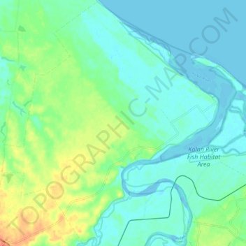
Name: Miara topographic map, elevation, terrain.

Location: Miara, Bundaberg Region, Queensland, 4673, Australia (-24.72227 152.11246 -24.63014 152.20465)

Average elevation: 12 m

Minimum elevation: -4 m

Maximum elevation: 42 m

Other topographic maps

Click on a map to view its topography, its elevation and its terrain.

Gin Gin

Australia > Queensland > Bundaberg Region > Gin Gin

Average elevation: 73 m

Isis River

Australia > Queensland > Bundaberg Region > Buxton

Average elevation: 12 m

Burrum River

Australia > Queensland > Bundaberg Region > Buxton

Average elevation: 20 m

Bundaberg

Australia > Queensland > Bundaberg Region

Average elevation: 18 m

Bundaberg

Australia > Queensland > Bundaberg Region

Average elevation: 18 m

Gear up for your next adventure:

🎒Fully Waterproof Backpack - Total protection for photography gear and electronics
👟Leg Gaiters - Keep debris, mud, and snow out of your boots
📷Outdoor Action Camera - Capture high-elevation views and rugged adventures
🧥Packable Rain Jacket - Breathable waterproof layer for unpredictable weather
🧰Emergency Multi-Tool - Compact multi-tool for outdoor survival

As an Amazon Associate, this site earns from qualifying purchases at no extra cost to you.