
Area G (Upper Similkameen/Hedley) topographic map
Interactive map
Click on the map to display elevation.
About this map
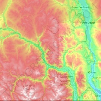
Name: Area G (Upper Similkameen/Hedley) topographic map, elevation, terrain.
Average elevation: 1,305 m
Minimum elevation: 277 m
Maximum elevation: 2,614 m
Other topographic maps
Click on a map to view its topography, its elevation and its terrain.
Penticton
Canada > British Columbia > Regional District of Okanagan-Similkameen
Penticton, Regional District of Okanagan-Similkameen, British Columbia, Canada
Average elevation: 702 m
Princeton
Canada > British Columbia > Regional District of Okanagan-Similkameen
Princeton, Regional District of Okanagan-Similkameen, British Columbia, Canada
Average elevation: 710 m
Oliver
Canada > British Columbia > Regional District of Okanagan-Similkameen
Oliver, Regional District of Okanagan-Similkameen, British Columbia, Canada
Average elevation: 369 m
Nickel Plate Lake
Canada > British Columbia > Regional District of Okanagan-Similkameen > Area G (Upper Similkameen/Hedley)
Nickel Plate Lake, Area G (Upper Similkameen/Hedley), Regional District of Okanagan-Similkameen, British Columbia, Canada
Average elevation: 1,881 m
Chapman Lake
Canada > British Columbia > Regional District of Okanagan-Similkameen > Area H (Manning Park/Tulameen/Siwash)
Chapman Lake, Area H (Manning Park/Tulameen/Siwash), Regional District of Okanagan-Similkameen, British Columbia, Canada
Average elevation: 1,669 m
Summerland
Canada > British Columbia > Regional District of Okanagan-Similkameen
Summerland, Regional District of Okanagan-Similkameen, British Columbia, Canada
Average elevation: 696 m
Osoyoos
Canada > British Columbia > Regional District of Okanagan-Similkameen
Osoyoos, Regional District of Okanagan-Similkameen, British Columbia, Canada
Average elevation: 326 m
Blakeburn
Canada > British Columbia > Regional District of Okanagan-Similkameen > Area H (Manning Park/Tulameen/Siwash)
Blakeburn, Area H (Manning Park/Tulameen/Siwash), Regional District of Okanagan-Similkameen, British Columbia, Canada
Average elevation: 1,188 m
Okanagan Falls
Canada > British Columbia > Regional District of Okanagan-Similkameen > Area D (Skaha East/Okanagan Falls)
Okanagan Falls, Area D (Skaha East/Okanagan Falls), Regional District of Okanagan-Similkameen, British Columbia, V0H 1R0, Canada
Average elevation: 478 m
Area D (Skaha East/Okanagan Falls)
Canada > British Columbia > Regional District of Okanagan-Similkameen
Area D (Skaha East/Okanagan Falls), Regional District of Okanagan-Similkameen, British Columbia, Canada
Average elevation: 1,240 m
Bankeir
Canada > British Columbia > Regional District of Okanagan-Similkameen > Area H (Manning Park/Tulameen/Siwash)
Bankeir, Area H (Manning Park/Tulameen/Siwash), Regional District of Okanagan-Similkameen, British Columbia, Canada
Average elevation: 1,226 m
Faulder
Canada > British Columbia > Regional District of Okanagan-Similkameen > Area F (Trout Creek Valley)
Faulder, Area F (Trout Creek Valley), Regional District of Okanagan-Similkameen, British Columbia, Canada
Average elevation: 850 m
Agur Lake
Canada > British Columbia > Regional District of Okanagan-Similkameen > Area F (Trout Creek Valley)
Agur Lake, Area F (Trout Creek Valley), Regional District of Okanagan-Similkameen, British Columbia, Canada
Average elevation: 1,178 m
Keremeos
Canada > British Columbia > Regional District of Okanagan-Similkameen
Keremeos, Regional District of Okanagan-Similkameen, British Columbia, Canada
Average elevation: 441 m
Naramata
Canada > British Columbia > Regional District of Okanagan-Similkameen > Area E (Naramata/Greyback) > Naramata
Naramata, Area E (Naramata/Greyback), Regional District of Okanagan-Similkameen, British Columbia, V0H 1N0, Canada
Average elevation: 414 m
White Lake Grasslands Protected Area
Canada > British Columbia > Regional District of Okanagan-Similkameen > Area I (Skaha West/Kaleden/Apex)
White Lake Grasslands Protected Area, Area I (Skaha West/Kaleden/Apex), Regional District of Okanagan-Similkameen, British Columbia, Canada
Average elevation: 664 m
Olivine Mountain
Canada > British Columbia > Regional District of Okanagan-Similkameen > Area H (Manning Park/Tulameen/Siwash)
Olivine Mountain, Area H (Manning Park/Tulameen/Siwash), Regional District of Okanagan-Similkameen, British Columbia, Canada
Average elevation: 1,537 m
Chute Lake
Canada > British Columbia > Regional District of Okanagan-Similkameen > Area E (Naramata/Greyback)
Chute Lake, Area E (Naramata/Greyback), Regional District of Okanagan-Similkameen, British Columbia, Canada
Average elevation: 1,273 m
Skaha Lake
Canada > British Columbia > Regional District of Okanagan-Similkameen > Area I (Skaha West/Kaleden/Apex) > Kaleden
Skaha Lake, Kaleden, Area I (Skaha West/Kaleden/Apex), Regional District of Okanagan-Similkameen, British Columbia, Canada
Average elevation: 701 m
Allenby
Canada > British Columbia > Regional District of Okanagan-Similkameen > Area H (Manning Park/Tulameen/Siwash)
Allenby, Area H (Manning Park/Tulameen/Siwash), Regional District of Okanagan-Similkameen, British Columbia, V0X 1W0, Canada
Average elevation: 850 m
Area C (Inkaneep/Willowbrook)
Canada > British Columbia > Regional District of Okanagan-Similkameen
Area C (Inkaneep/Willowbrook), Regional District of Okanagan-Similkameen, British Columbia, V0H 1T1, Canada
Average elevation: 1,239 m
Rampart Lake
Canada > British Columbia > Regional District of Okanagan-Similkameen > Area H (Manning Park/Tulameen/Siwash)
Rampart Lake, Area H (Manning Park/Tulameen/Siwash), Regional District of Okanagan-Similkameen, British Columbia, Canada
Average elevation: 1,333 m
Marron Valley
Canada > British Columbia > Regional District of Okanagan-Similkameen > Area I (Skaha West/Kaleden/Apex)
Marron Valley, Area I (Skaha West/Kaleden/Apex), Regional District of Okanagan-Similkameen, British Columbia, Canada
Average elevation: 772 m
Area F (Trout Creek Valley)
Canada > British Columbia > Regional District of Okanagan-Similkameen
Area F (Trout Creek Valley), Regional District of Okanagan-Similkameen, British Columbia, Canada
Average elevation: 1,205 m
Manning Park
Canada > British Columbia > Regional District of Okanagan-Similkameen > Area H (Manning Park/Tulameen/Siwash)
Manning Park, Area H (Manning Park/Tulameen/Siwash), Regional District of Okanagan-Similkameen, British Columbia, Canada
Average elevation: 1,420 m
Kaleden
Canada > British Columbia > Regional District of Okanagan-Similkameen > Area I (Skaha West/Kaleden/Apex)
Kaleden, Area I (Skaha West/Kaleden/Apex), Regional District of Okanagan-Similkameen, British Columbia, V0H 1R3, Canada
Average elevation: 454 m
Tulameen
Canada > British Columbia > Regional District of Okanagan-Similkameen > Area H (Manning Park/Tulameen/Siwash)
Tulameen, Area H (Manning Park/Tulameen/Siwash), Regional District of Okanagan-Similkameen, British Columbia, V0X 2L0, Canada
Average elevation: 923 m
Lightning Lake
Canada > British Columbia > Regional District of Okanagan-Similkameen > Area H (Manning Park/Tulameen/Siwash)
Lightning Lake, Area H (Manning Park/Tulameen/Siwash), Regional District of Okanagan-Similkameen, British Columbia, Canada
Average elevation: 1,418 m
Greyback Lake
Canada > British Columbia > Regional District of Okanagan-Similkameen > Area E (Naramata/Greyback)
Greyback Lake, Area E (Naramata/Greyback), Regional District of Okanagan-Similkameen, British Columbia, Canada
Average elevation: 1,627 m
Cawston
Canada > British Columbia > Regional District of Okanagan-Similkameen > Area B (Cawston/Lower Similkameen)
Cawston, Area B (Cawston/Lower Similkameen), Regional District of Okanagan-Similkameen, British Columbia, V0X 1C0, Canada
Average elevation: 410 m
Penticton
Canada > British Columbia > Regional District of Okanagan-Similkameen > Penticton
Penticton, Regional District of Okanagan-Similkameen, British Columbia, V2A 5A9, Canada
Average elevation: 1,044 m
Okanagan Highland
Canada > British Columbia > Regional District of Okanagan-Similkameen > Area E (Naramata/Greyback)
Okanagan Highland, Area E (Naramata/Greyback), Regional District of Okanagan-Similkameen, British Columbia, V2A 8T7, Canada
Average elevation: 816 m
Area A (Osoyoos Lake)
Canada > British Columbia > Regional District of Okanagan-Similkameen
Area A (Osoyoos Lake), Regional District of Okanagan-Similkameen, British Columbia, Canada
Average elevation: 1,012 m
Area H (Manning Park/Tulameen/Siwash)
Canada > British Columbia > Regional District of Okanagan-Similkameen
Area H (Manning Park/Tulameen/Siwash), Regional District of Okanagan-Similkameen, British Columbia, Canada
Average elevation: 1,337 m
Area I (Skaha West/Kaleden/Apex)
Canada > British Columbia > Regional District of Okanagan-Similkameen
Area I (Skaha West/Kaleden/Apex), Regional District of Okanagan-Similkameen, British Columbia, Canada
Average elevation: 1,308 m
Apex Mountain
Canada > British Columbia > Regional District of Okanagan-Similkameen > Area G (Upper Similkameen/Hedley)
Apex Mountain, Area G (Upper Similkameen/Hedley), Regional District of Okanagan-Similkameen, British Columbia, Canada
Average elevation: 2,002 m