Geolocate

Lazise topographic map

Click on the map to display elevation.

About this map

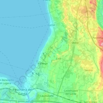
Name: Lazise topographic map, elevation, terrain.

Location: Lazise, Verona, Veneto, 37017, Italy (45.43763 10.63764 45.51998 10.78325)

Average elevation: 101 m

Minimum elevation: 62 m

Maximum elevation: 252 m

Other topographic maps

Click on a map to view its topography, its elevation and its terrain.

Spiazzi

Italy > Veneto > Verona

Average elevation: 709 m

Pezzo

Italy > Veneto > Verona > Bosco Chiesanuova

Average elevation: 1,086 m

Casale

Italy > Veneto > Verona > San Martino Buon Albergo

Average elevation: 190 m

Pazzon

Italy > Veneto > Verona

Average elevation: 501 m

Bosco

Italy > Veneto > Verona > Presina

Average elevation: 20 m

Provalo

Italy > Veneto > Verona > Sant'Anna d'Alfaedo

Average elevation: 980 m

Masetti

Italy > Veneto > Verona > San Bonifacio

Average elevation: 26 m

Santa Margherita

Italy > Veneto > Verona

Average elevation: 279 m

Azzano

Italy > Veneto > Verona > Castel d'Azzano

Average elevation: 47 m

Isola del Sogno

Italy > Veneto > Verona > Cassone

Average elevation: 152 m

Sengie

Italy > Veneto > Verona > Grezzana > Lugo

Average elevation: 536 m

Miega

Italy > Veneto > Verona > Veronella > Miega

Average elevation: 19 m

Cavalcaselle

Italy > Veneto > Verona > Cavalcaselle

Average elevation: 96 m

Arzerè

Italy > Veneto > Verona > Arzerè

Average elevation: 646 m

Gear up for your next adventure:

🥾Hiking Shoes - Durable and comfortable shoes for trail hiking
🧊Insulated Water Bottle - Keeps drinks cold in summer and prevents freezing in winter
🧢Outdoor Visor - Breathable visor for sunny hikes
🥾Approach Boots - Comfortable boots for hiking and climbing approaches
🥫Freeze-Dried Meals - Lightweight, high-calorie nutrition for multi-day treks

As an Amazon Associate, this site earns from qualifying purchases at no extra cost to you.