
Make a donation
Gear up for your next adventure:
As an Amazon Associate, this site earns from qualifying purchases at no extra cost to you.
Dupnitsa topographic map
Click on the map to display elevation.
Make a donation
Gear up for your next adventure:
As an Amazon Associate, this site earns from qualifying purchases at no extra cost to you.
Dupnitsa
Dupnitsa is located at an altitude of 500 m in a valley, surrounded by hills. Its location, as seen from above, resembles a hole (дупка, dupka in Bulgarian), hence the name Dupnitsa. There are five rivers flowing in the vicinity.
Make a donation
Gear up for your next adventure:
As an Amazon Associate, this site earns from qualifying purchases at no extra cost to you.
About this map
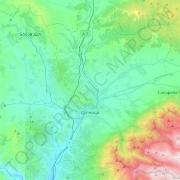
Name: Dupnitsa topographic map, elevation, terrain.
Location: Dupnitsa, Kyustendil, Bulgaria (42.17250 23.00407 42.41081 23.32018)
Average elevation: 854 m
Minimum elevation: 382 m
Maximum elevation: 2,651 m
Make a donation
Gear up for your next adventure:
As an Amazon Associate, this site earns from qualifying purchases at no extra cost to you.
Other topographic maps
Click on a map to view its topography, its elevation and its terrain.