
Thank you for supporting this site ❤️
Make a donation
Make a donation
Gear up for your next adventure:
As an Amazon Associate, this site earns from qualifying purchases at no extra cost to you.
Borovets topographic map
Click on the map to display elevation.
Thank you for supporting this site ❤️
Make a donation
Make a donation
Gear up for your next adventure:
As an Amazon Associate, this site earns from qualifying purchases at no extra cost to you.
About this map
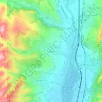
Name: Borovets topographic map, elevation, terrain.
Location: Borovets, Kocherinovo, Kyustendil, 2640, Bulgaria (42.08435 23.00161 42.12435 23.04161)
Average elevation: 412 m
Minimum elevation: 346 m
Maximum elevation: 574 m
Thank you for supporting this site ❤️
Make a donation
Make a donation
Gear up for your next adventure:
As an Amazon Associate, this site earns from qualifying purchases at no extra cost to you.