Geolocate

Bowden topographic map

Click on the map to display elevation.

About this map

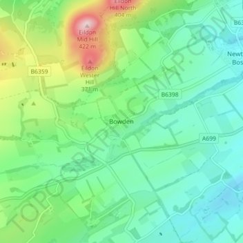
Name: Bowden topographic map, elevation, terrain.

Location: Bowden, Scottish Borders, Scotland, TD6 0SS, United Kingdom (55.54649 -2.72842 55.58649 -2.68842)

Average elevation: 181 m

Minimum elevation: 97 m

Maximum elevation: 408 m

Gear up for your next adventure:

🧦Crew Hiking Socks - Comfortable socks for long-distance hikes
🧢Beanie Hat - Keep your head warm in cold weather
💡LED Headlamp - Hands-free illumination for night hiking and camping
🧢Sun Hat - Wide-brim hat for sun protection
🥾Trail Running Boots - Durable shoes designed for trail running

As an Amazon Associate, this site earns from qualifying purchases at no extra cost to you.