
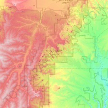
Bryce Canyon National Park topographic map
Interactive map
Click on the map to display elevation.
About this map
Name: Bryce Canyon National Park topographic map, elevation, terrain.
Average elevation: 2,259 m
Minimum elevation: 1,640 m
Maximum elevation: 2,902 m
Bryce Canyon National Park (/braɪs/) is an American national park located in southwestern Utah. The major feature of the park is Bryce Canyon, which despite its name, is not a canyon, but a collection of giant natural amphitheaters along the eastern side of the Paunsaugunt Plateau. Bryce is distinctive due to geological structures called hoodoos, formed by frost weathering and stream erosion of the river and lake bed sedimentary rocks. The red, orange, and white colors of the rocks provide spectacular views for park visitors. Bryce Canyon National Park is much smaller and sits at a much higher elevation than nearby Zion National Park. The rim at Bryce varies from 8,000 to 9,000 feet (2,400 to 2,700 m).
Other topographic maps
Click on a map to view its topography, its elevation and its terrain.
Hite Point
United States > Utah > Garfield County
Hite Point, Garfield County, Utah, United States
Average elevation: 1,348 m
Cannonville
United States > Utah > Garfield County
Cannonville, Garfield County, Utah, 84718, United States
Average elevation: 1,894 m
Panguitch Lake
United States > Utah > Garfield County
Panguitch Lake, Garfield County, Utah, United States
Average elevation: 2,528 m
Upper Calf Creek Fall
United States > Utah > Garfield County
Upper Calf Creek Fall, Garfield County, Utah, 84716, United States
Average elevation: 1,904 m
Piracy Point
United States > Utah > Garfield County
Piracy Point, Bryce Canyon Scenic Drive, Garfield County, Utah, United States
Average elevation: 2,551 m
Henderson Creek
United States > Utah > Garfield County
Henderson Creek, Garfield County, Utah, 84776, United States
Average elevation: 2,017 m
Antimony
United States > Utah > Garfield County
Antimony, Garfield County, Utah, 84712, United States
Average elevation: 2,061 m
Bryce Canyon
United States > Utah > Garfield County > Tropic
Bryce Canyon, Tropic, Garfield County, Utah, United States
Average elevation: 2,247 m
Escalante
United States > Utah > Garfield County
Escalante, Garfield County, Utah, 84726, United States
Average elevation: 1,781 m
Hatch
United States > Utah > Garfield County
Hatch, Garfield County, Utah, 84735, United States
Average elevation: 2,135 m
Bryce Canyon City
United States > Utah > Garfield County > Bryce Canyon City
Bryce Canyon City, Garfield County, Utah, 84764, United States
Average elevation: 2,337 m
Panguitch
United States > Utah > Garfield County > Panguitch
Panguitch, Garfield County, Utah, 87459, United States
Average elevation: 2,081 m
Andy Miller Flats
United States > Utah > Garfield County
Andy Miller Flats, Garfield County, Utah, United States
Average elevation: 1,604 m
Panguitch
United States > Utah > Garfield County
Panguitch, Garfield County, Utah, United States
Average elevation: 2,043 m
Capitol Reef National Park
United States > Utah > Garfield County
Capitol Reef National Park, Garfield County, Utah, United States
Average elevation: 1,963 m