Geolocate

Bryce Canyon topographic map

Click on the map to display elevation.

About this map

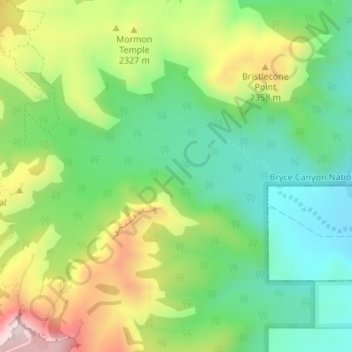
Name: Bryce Canyon topographic map, elevation, terrain.

Location: Bryce Canyon, Tropic, Garfield County, Utah, United States (37.61261 -112.15919 37.61956 -112.12655)

Average elevation: 2,247 m

Minimum elevation: 2,066 m

Maximum elevation: 2,547 m

Gear up for your next adventure:

🥾Waterproof Hiking Shoes - Durable shoes for wet and rugged trails
🧢Outdoor Cap - Protective cap for sun and rain during hikes
🧣Evaporative Cooling Towel - Beat the heat during intense summer climbs
🔦LED Flashlight - Powerful and long-lasting flashlight for camping and emergencies
🥾Mountain Trail Shoes - High-traction shoes for mountain trails

As an Amazon Associate, this site earns from qualifying purchases at no extra cost to you.