Geolocate

Hatch topographic map

Click on the map to display elevation.

About this map

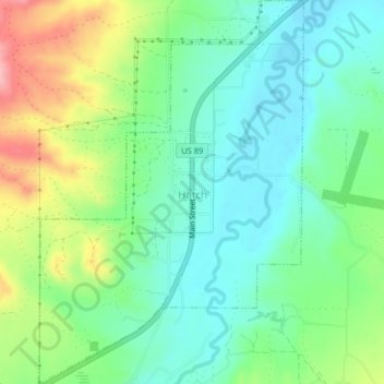
Name: Hatch topographic map, elevation, terrain.

Location: Hatch, Garfield County, Utah, 84735, United States (37.63393 -112.45056 37.66585 -112.42272)

Average elevation: 2,135 m

Minimum elevation: 2,091 m

Maximum elevation: 2,227 m

Gear up for your next adventure:

🕯️Camping Lantern - Illuminates your entire campsite with high-efficiency LEDs
🥾Trail Running Boots - Durable shoes designed for trail running
🧴Waterproofing Spray - Restore the DWR coating on jackets and tents
🥾Hiking Gaiters - Protect legs and shoes from mud, snow, and debris
Camping Groundsheet - Protect your tent from moisture and dirt

As an Amazon Associate, this site earns from qualifying purchases at no extra cost to you.