
Make a donation
Gear up for your next adventure:
As an Amazon Associate, this site earns from qualifying purchases at no extra cost to you.
Rioja topographic map
Click on the map to display elevation.
Make a donation
Gear up for your next adventure:
As an Amazon Associate, this site earns from qualifying purchases at no extra cost to you.
Rioja
The mountains in La Rioja are part of the Iberian System. This mountain range extends to the south of the Ebro river, parallel to it at a distance of about 40 to 60 km (25 to 37 miles), with altitudes ranging between 1,000 and 2,000 m (3,300 and 6,600 feet). From the mountain range the Sierra de la Demanda runs northwards, into the heart of La Rioja, incorporating Monte San Lorenzo which, at 2,271 m (7,451 ft), is the highest peak in the province. Other mountains include Sierra de Camero Viejo, Sierra de Camero Nuevo, Sierra de Cebollera, and Picos de Urbión.
Make a donation
Gear up for your next adventure:
As an Amazon Associate, this site earns from qualifying purchases at no extra cost to you.
About this map
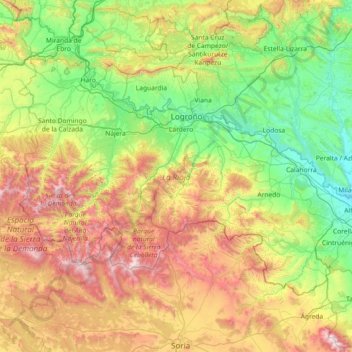
Name: Rioja topographic map, elevation, terrain.
Location: Rioja, Spain (41.91903 -3.13427 42.64426 -1.67870)
Average elevation: 879 m
Minimum elevation: 270 m
Maximum elevation: 2,297 m
Make a donation
Gear up for your next adventure:
As an Amazon Associate, this site earns from qualifying purchases at no extra cost to you.
Other topographic maps
Click on a map to view its topography, its elevation and its terrain.
Make a donation
Gear up for your next adventure:
As an Amazon Associate, this site earns from qualifying purchases at no extra cost to you.
Make a donation
Gear up for your next adventure:
As an Amazon Associate, this site earns from qualifying purchases at no extra cost to you.