Geolocate

Logroño topographic map

Click on the map to display elevation.

About this map

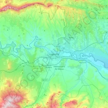
Name: Logroño topographic map, elevation, terrain.

Location: Logroño, Rioja, 26003, Spain (42.30612 -2.59967 42.62612 -2.27967)

Average elevation: 592 m

Minimum elevation: 332 m

Maximum elevation: 1,495 m

Gear up for your next adventure:

🛌Insulated Sleeping Pad - Critical thermal barrier between you and the cold ground
💧Collapsible Water Bottle - Space-saving water bottle for outdoor activities
🛶Kayak Dry Bag - Waterproof storage for kayaking adventures
🧢Outdoor Cap - Protective cap for sun and rain during hikes
🛰️Satellite Messenger - Emergency communication for areas with no cell service

As an Amazon Associate, this site earns from qualifying purchases at no extra cost to you.