
Wellington North topographic map
Interactive map
Click on the map to display elevation.
About this map
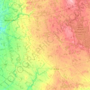
Name: Wellington North topographic map, elevation, terrain.
Location: Wellington North, Wellington County, Ontario, Canada (43.78363 -80.77132 44.02598 -80.38792)
Average elevation: 456 m
Minimum elevation: 386 m
Maximum elevation: 524 m
Other topographic maps
Click on a map to view its topography, its elevation and its terrain.
Arthur
Canada > Ontario > Wellington County > Wellington North
Arthur, Wellington North, Wellington County, Ontario, N0G 1A0, Canada
Average elevation: 460 m
Centre Wellington
Canada > Ontario > Wellington County
Centre Wellington, Wellington County, Ontario, Canada
Average elevation: 419 m
Eramosa River
Canada > Ontario > Wellington County > Guelph/Eramosa
Eramosa River, Guelph/Eramosa, Wellington County, Golden Horseshoe, Ontario, Canada
Average elevation: 384 m
Ballinafad
Canada > Ontario > Wellington County > Erin
Ballinafad, Erin, Wellington County, Ontario, N0B 1H0, Canada
Average elevation: 374 m
Belwood Quarry
Canada > Ontario > Wellington County > Centre Wellington
Belwood Quarry, Centre Wellington, Wellington County, Ontario, Canada
Average elevation: 424 m
Fergus
Canada > Ontario > Wellington County > Centre Wellington
Fergus, Centre Wellington, Wellington County, Southwestern Ontario, Ontario, N1M 1P6, Canada
Average elevation: 415 m
Elora
Canada > Ontario > Wellington County > Centre Wellington
Elora, Centre Wellington, Wellington County, Ontario, N1M 1K4, Canada
Average elevation: 395 m
Mount Forest
Canada > Ontario > Wellington County > Wellington North
Mount Forest, Wellington North, Wellington County, Ontario, N0G 2L3, Canada
Average elevation: 417 m
Elora Gorge
Canada > Ontario > Wellington County > Centre Wellington
Elora Gorge, Centre Wellington, Wellington County, Ontario, N0B 1S0, Canada
Average elevation: 385 m
Erin
Canada > Ontario > Wellington County
Erin, Wellington County, Ontario, Canada
Average elevation: 390 m
Mapleton
Canada > Ontario > Wellington County
Mapleton, Wellington County, Southwestern Ontario, Ontario, Canada
Average elevation: 411 m
Conn
Canada > Ontario > Wellington County > Wellington North
Conn, Wellington North, Wellington County, Southwestern Ontario, Ontario, Canada
Average elevation: 475 m
Puslinch
Canada > Ontario > Wellington County
Puslinch, Wellington County, Ontario, Canada
Average elevation: 317 m
Drayton
Canada > Ontario > Wellington County > Mapleton
Drayton, Mapleton, Wellington County, Southwestern Ontario, Ontario, N0G 1P0, Canada
Average elevation: 419 m
Luther Lake
Canada > Ontario > Wellington County > Wellington North
Luther Lake, Wellington North, Wellington County, Southwestern Ontario, Ontario, Canada
Average elevation: 482 m
Alma
Canada > Ontario > Wellington County > Mapleton
Alma, Mapleton, Wellington County, Southwestern Ontario, Ontario, N0B 1A0, Canada
Average elevation: 445 m
Harriston
Canada > Ontario > Wellington County
Harriston, Minto, Wellington County, Southwestern Ontario, Ontario, N0G 1Z0, Canada
Average elevation: 386 m
Guelph/Eramosa
Canada > Ontario > Wellington County
Guelph/Eramosa, Wellington County, Ontario, Canada
Average elevation: 361 m
Guelph Lake
Canada > Ontario > Wellington County > Guelph/Eramosa > Eramosa
Guelph Lake, Eramosa, Guelph/Eramosa, Wellington County, Ontario, Canada
Average elevation: 355 m
Rockwood
Canada > Ontario > Wellington County > Guelph/Eramosa
Rockwood, Guelph/Eramosa, Wellington County, Ontario, N0B 2K0, Canada
Average elevation: 364 m
Conestoga Lake
Canada > Ontario > Wellington County > Mapleton
Conestoga Lake, Mapleton, Wellington County, Southwestern Ontario, Ontario, Canada
Average elevation: 412 m
Belwood Lake Boat Launch
Canada > Ontario > Wellington County > Centre Wellington
Belwood Lake Boat Launch, Centre Wellington, Wellington County, Southwestern Ontario, Ontario, Canada
Average elevation: 443 m
Eramosa
Canada > Ontario > Wellington County > Guelph/Eramosa > Eramosa
Eramosa, Guelph/Eramosa, Wellington County, Southwestern Ontario, Ontario, N1E 0G1, Canada
Average elevation: 361 m
Hillsburgh
Canada > Ontario > Wellington County > Erin
Hillsburgh, Erin, Wellington County, Ontario, N0B 1Z0, Canada
Average elevation: 449 m
Brisbane
Canada > Ontario > Wellington County > Erin
Brisbane, Erin, Wellington County, Ontario, N0B 1T0, Canada
Average elevation: 411 m