
Guelph/Eramosa topographic map
Interactive map
Click on the map to display elevation.
About this map
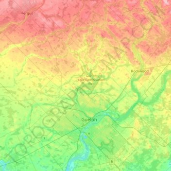
Name: Guelph/Eramosa topographic map, elevation, terrain.
Location: Guelph/Eramosa, Wellington County, Ontario, Canada (43.46865 -80.41000 43.72528 -80.08539)
Average elevation: 361 m
Minimum elevation: 291 m
Maximum elevation: 450 m
Wellington County trails, hiking, mountain biking, running and outdoor activities
Other topographic maps
Click on a map to view its topography, its elevation and its terrain.
Belwood Lake Boat Launch
Canada > Ontario > Wellington County > Centre Wellington
Average elevation: 443 m