
Fall River topographic map
Interactive map
Click on the map to display elevation.
About this map
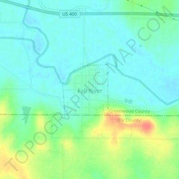
Name: Fall River topographic map, elevation, terrain.
Location: Fall River, Greenwood County, Kansas, 67047, United States (37.60418 -96.03323 37.61180 -96.02461)
Average elevation: 291 m
Minimum elevation: 275 m
Maximum elevation: 328 m
Other topographic maps
Click on a map to view its topography, its elevation and its terrain.
Madison
United States > Kansas > Greenwood County
Madison, Greenwood County, Kansas, 66860, United States
Average elevation: 347 m
Eureka
United States > Kansas > Greenwood County
Eureka, Greenwood County, Kansas, 67045, United States
Average elevation: 341 m
Piedmont
United States > Kansas > Greenwood County
Piedmont, Greenwood County, Kansas, 67122, United States
Average elevation: 375 m
Virgil
United States > Kansas > Greenwood County
Virgil, Greenwood County, Kansas, 66870, United States
Average elevation: 309 m
Severy
United States > Kansas > Greenwood County
Severy, Greenwood County, Kansas, 67137, United States
Average elevation: 338 m
Neal
United States > Kansas > Greenwood County
Neal, Greenwood County, Kansas, 66863, United States
Average elevation: 305 m
Climax
United States > Kansas > Greenwood County
Climax, Greenwood County, Kansas, United States
Average elevation: 313 m
Hamilton
United States > Kansas > Greenwood County
Hamilton, Greenwood County, Kansas, 66853, United States
Average elevation: 338 m
Quincy
United States > Kansas > Greenwood County > Quincy
Quincy, Greenwood County, Kansas, United States
Average elevation: 294 m
Temple Knob
United States > Kansas > Greenwood County
Temple Knob, Greenwood County, Kansas, United States
Average elevation: 460 m