
Make a donation
Gear up for your next adventure:
As an Amazon Associate, this site earns from qualifying purchases at no extra cost to you.
Neal topographic map
Click on the map to display elevation.
Make a donation
Gear up for your next adventure:
As an Amazon Associate, this site earns from qualifying purchases at no extra cost to you.
About this map
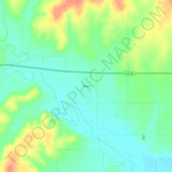
Name: Neal topographic map, elevation, terrain.
Location: Neal, Greenwood County, Kansas, 66863, United States (37.81420 -96.10027 37.85420 -96.06027)
Average elevation: 305 m
Minimum elevation: 284 m
Maximum elevation: 341 m
Make a donation
Gear up for your next adventure:
As an Amazon Associate, this site earns from qualifying purchases at no extra cost to you.
Other topographic maps
Click on a map to view its topography, its elevation and its terrain.
Make a donation
Gear up for your next adventure:
As an Amazon Associate, this site earns from qualifying purchases at no extra cost to you.
Climax
United States > Kansas > Greenwood County
Climax was founded in 1884. It was named from its elevation, or Climax College in Kalamazoo, Michigan.
Average elevation: 313 m