Geolocate

Weimar topographic map

Click on the map to display elevation.

About this map

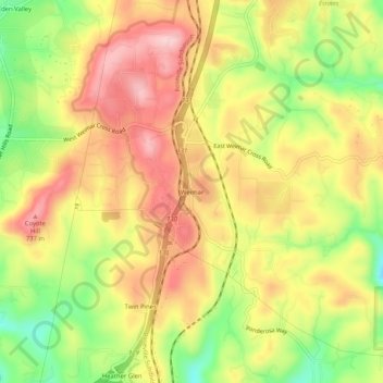
Name: Weimar topographic map, elevation, terrain.

Location: Weimar, Placer County, California, 95736, United States (39.01740 -120.99244 39.05740 -120.95244)

Average elevation: 662 m

Minimum elevation: 551 m

Maximum elevation: 751 m

Other topographic maps

Click on a map to view its topography, its elevation and its terrain.

Avery's Pond

United States > California > Placer County

Average elevation: 189 m

Lincoln

United States > California > Placer County

Average elevation: 60 m

Tahoe Vista

United States > California > Placer County > Kings Beach

Average elevation: 2,025 m

Lincoln

United States > California > Placer County

Average elevation: 34 m

Dollar Point

United States > California > Placer County

Average elevation: 1,955 m

Auburn Ravine

United States > California > Placer County > Auburn

Average elevation: 248 m

Deer Lake

United States > California > Placer County

Average elevation: 2,019 m

Gear up for your next adventure:

🧥Thermal Fleece Jacket - Versatile insulation for changing mountain temperatures
🧥Ultralight Puffy Jacket - Maximum warmth that packs down to the size of an orange
🧤Thermal Hiking Gloves - Grip-enhanced gloves for cold-weather altitude trekking
💡Compact LED Flashlight - Powerful and portable flashlight for outdoor use
🛁Quick-Dry Microfiber Towel - Space-saving towel that dries rapidly on the move

As an Amazon Associate, this site earns from qualifying purchases at no extra cost to you.