
Roseville topographic map
Click on the map to display elevation.
Roseville
Roseville has a hot-summer Mediterranean climate that is characterized by cool, wet, usually snowless winters and hot, dry summers (Köppen Csa). The wet season is generally October through April. Because Roseville is east of Sacramento and at a higher elevation, it receives slightly more rainfall. Average daily high temperatures range from 53 °F (12 °C) in January to 94 °F (34 °C) in July. Daily low temperatures range from 39 °F (4 °C) in winter to 61 °F (16 °C) in summer.
About this map
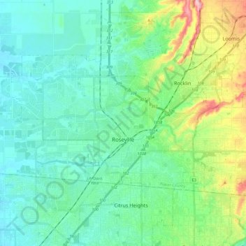
Name: Roseville topographic map, elevation, terrain.
Location: Roseville, Placer County, California, United States (38.71635 -121.44670 38.82435 -121.18416)
Average elevation: 67 m
Minimum elevation: 17 m
Maximum elevation: 290 m
Other topographic maps
Click on a map to view its topography, its elevation and its terrain.
Donner Peak
United States > California > Placer County
Donner Peak is an 8,019-foot-elevation (2,444-meter) summit in Placer County, California, United States.
Average elevation: 2,171 m
Carnelian Bay
United States > California > Placer County
For statistical purposes, the United States Census Bureau has defined Carnelian Bay as a census-designated place (CDP). The census definition of the area may not precisely correspond to local understanding of the area with the same name. The population was 524 at the 2010 census. The elevation is 6,325 feet…
Average elevation: 1,977 m
Blue Canyon
United States > California > Placer County
Blue Canyon (also, Blue Cañon) is an unincorporated community in Placer County, California. Blue Canyon is located 4 miles (6.4 km) southwest of Emigrant Gap. It lies at an elevation of 4695 feet (1431 m).
Average elevation: 1,452 m