Geolocate

Lincoln topographic map

Click on the map to display elevation.

About this map

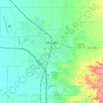
Name: Lincoln topographic map, elevation, terrain.

Location: Lincoln, Placer County, California, 95648, United States (38.83915 -121.35846 38.92646 -121.22793)

Average elevation: 60 m

Minimum elevation: 25 m

Maximum elevation: 190 m

Gear up for your next adventure:

Bushcraft Tarp - Versatile emergency shelter or gear protection
Lightweight Backpacking Tent - Compact tent for efficient hiking trips
🧥Softshell Jacket - Windproof and breathable jacket for hiking
🧴First Aid Kit - Essential first aid supplies for outdoor emergencies
🎒Hiking Backpack - Lightweight and ergonomic backpacks for day hikes or multi-day treks

As an Amazon Associate, this site earns from qualifying purchases at no extra cost to you.