Geolocate

Barnetby le Wold topographic map

Click on the map to display elevation.

About this map

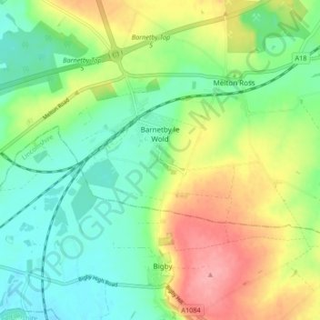
Name: Barnetby le Wold topographic map, elevation, terrain.

Location: Barnetby le Wold, North Lincolnshire, England, United Kingdom (53.55577 -0.42877 53.58268 -0.34585)

Average elevation: 40 m

Minimum elevation: 4 m

Maximum elevation: 99 m

Other topographic maps

Click on a map to view its topography, its elevation and its terrain.

Cleatham

United Kingdom > England > North Lincolnshire

Average elevation: 36 m

Ealand

United Kingdom > England > North Lincolnshire

Average elevation: 4 m

Crowle

United Kingdom > England > North Lincolnshire

Average elevation: 3 m

Bracon

United Kingdom > England > North Lincolnshire

Average elevation: 7 m

Keadby

United Kingdom > England > North Lincolnshire

Average elevation: 3 m

Beltoft

United Kingdom > England > North Lincolnshire

Average elevation: 5 m

Gear up for your next adventure:

🧥Thermal Layer - Insulating layer for cold outdoor conditions
🧣Evaporative Cooling Towel - Beat the heat during intense summer climbs
🦟Insect Repellent - Keep mosquitoes and black flies away in wooded areas
👟Leg Gaiters - Keep debris, mud, and snow out of your boots
🧤Rechargeable Heated Gloves - Extreme warmth for Canadian winter expeditions

As an Amazon Associate, this site earns from qualifying purchases at no extra cost to you.