Geolocate

Christmas topographic map

Click on the map to display elevation.

About this map

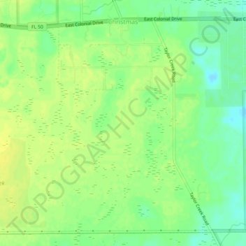
Name: Christmas topographic map, elevation, terrain.

Location: Christmas, Orange County, Florida, United States (28.50128 -81.01785 28.53968 -80.98056)

Average elevation: 15 m

Minimum elevation: 4 m

Maximum elevation: 22 m

Other topographic maps

Click on a map to view its topography, its elevation and its terrain.

Orlando

United States > Florida > Orange County

Average elevation: 29 m

Wedgefield

United States > Florida > Orange County > Wedgefield

Average elevation: 20 m

Lockhart

United States > Florida > Orange County > Lockhart

Average elevation: 30 m

Apopka

United States > Florida > Orange County

Average elevation: 27 m

Windermere

United States > Florida > Orange County

Average elevation: 34 m

Dr. Phillips

United States > Florida > Orange County

Average elevation: 34 m

Lockwood

United States > Florida > Orange County

Average elevation: 20 m

Winter Park

United States > Florida > Orange County

The city is northeast of and adjacent to Orlando. Elevation ranges between 66 and 97 feet (20 and 30 m) above sea level.

Average elevation: 30 m

Maitland

United States > Florida > Orange County

Average elevation: 30 m

Barnett Park

United States > Florida > Orange County

Average elevation: 32 m

Gear up for your next adventure:

🥤Collapsible Travel Cup - Saves space and weight in your mess kit
🏃Hydration Running Vest - Carry water and maps close to your body for speed
🧦Hiking Liner Socks - Thin base layer to prevent friction and blisters
🧰Survival Kit - Essential gear for emergencies in the wilderness
🔋Emergency Crank Radio - Weather alerts and power without needing batteries

As an Amazon Associate, this site earns from qualifying purchases at no extra cost to you.