
Make a donation
Gear up for your next adventure:
As an Amazon Associate, this site earns from qualifying purchases at no extra cost to you.
Te Hiku Community topographic map
Click on the map to display elevation.
Make a donation
Gear up for your next adventure:
As an Amazon Associate, this site earns from qualifying purchases at no extra cost to you.
About this map
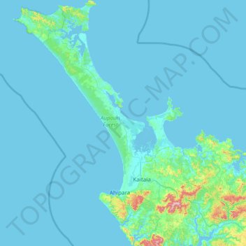
Name: Te Hiku Community topographic map, elevation, terrain.
Average elevation: 29 m
Minimum elevation: 0 m
Maximum elevation: 701 m
Make a donation
Gear up for your next adventure:
As an Amazon Associate, this site earns from qualifying purchases at no extra cost to you.
Other topographic maps
Click on a map to view its topography, its elevation and its terrain.
Waihou River
New Zealand > Northland > Far North District > Kaikohe-Hokianga Community
Average elevation: 184 m
Kaikohe
New Zealand > Northland > Far North District > Kaikohe-Hokianga Community
Average elevation: 216 m
Make a donation
Gear up for your next adventure:
As an Amazon Associate, this site earns from qualifying purchases at no extra cost to you.
Ōkaihau
New Zealand > Northland > Far North District > Kaikohe-Hokianga Community
Average elevation: 207 m
Purerua Peninsula
New Zealand > Northland > Far North District > Bay of Islands
Average elevation: 34 m
Make a donation
Gear up for your next adventure:
As an Amazon Associate, this site earns from qualifying purchases at no extra cost to you.
Opononi
New Zealand > Northland > Far North District > Kaikohe-Hokianga Community
Average elevation: 51 m
Lake Ōmāpere
New Zealand > Northland > Far North District > Kaikohe-Hokianga Community
Average elevation: 243 m
Make a donation
Gear up for your next adventure:
As an Amazon Associate, this site earns from qualifying purchases at no extra cost to you.
Ahiaruhe Shell Bank
New Zealand > Northland > Far North District > Te Hiku Community
Average elevation: 3 m
Make a donation
Gear up for your next adventure:
As an Amazon Associate, this site earns from qualifying purchases at no extra cost to you.
Rawene
New Zealand > Northland > Far North District > Kaikohe-Hokianga Community
Average elevation: 8 m
Whirinaki River
New Zealand > Northland > Far North District > Kaikohe-Hokianga Community
Average elevation: 368 m
Make a donation
Gear up for your next adventure:
As an Amazon Associate, this site earns from qualifying purchases at no extra cost to you.
Kerikeri River
New Zealand > Northland > Far North District > Bay of Islands > Waipapa
Average elevation: 72 m
Lake Waiparera
New Zealand > Northland > Far North District > Te Hiku Community
Average elevation: 32 m
Make a donation
Gear up for your next adventure:
As an Amazon Associate, this site earns from qualifying purchases at no extra cost to you.
Paihia
New Zealand > Northland > Far North District > Bay of Islands-Whangaroa Community
Average elevation: 27 m
Tautoro
New Zealand > Northland > Far North District > Kaikohe-Hokianga Community
Average elevation: 136 m
Make a donation
Gear up for your next adventure:
As an Amazon Associate, this site earns from qualifying purchases at no extra cost to you.
Rangitoto
New Zealand > Northland > Far North District > Kaikohe-Hokianga Community
Average elevation: 24 m
Te Tii Waitangi Marae
New Zealand > Northland > Far North District > Bay of Islands-Whangaroa Community > Paihia
Average elevation: 14 m
Onewhero Bay
New Zealand > Northland > Far North District > Bay of Islands-Whangaroa Community
Average elevation: 18 m
Make a donation
Gear up for your next adventure:
As an Amazon Associate, this site earns from qualifying purchases at no extra cost to you.
Russell
New Zealand > Northland > Far North District > Bay of Islands-Whangaroa Community
Average elevation: 12 m
Kerikeri
New Zealand > Northland > Far North District > Bay of Islands-Whangaroa Community
Average elevation: 76 m
Make a donation
Gear up for your next adventure:
As an Amazon Associate, this site earns from qualifying purchases at no extra cost to you.