
Make a donation
Gear up for your next adventure:
As an Amazon Associate, this site earns from qualifying purchases at no extra cost to you.
Rawene topographic map
Click on the map to display elevation.
Make a donation
Gear up for your next adventure:
As an Amazon Associate, this site earns from qualifying purchases at no extra cost to you.
About this map
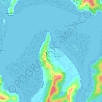
Name: Rawene topographic map, elevation, terrain.
Average elevation: 8 m
Minimum elevation: 0 m
Maximum elevation: 84 m
Make a donation
Gear up for your next adventure:
As an Amazon Associate, this site earns from qualifying purchases at no extra cost to you.
Other topographic maps
Click on a map to view its topography, its elevation and its terrain.
Awaroa River
New Zealand > Northland > Far North District > Kaikohe-Hokianga Community
Average elevation: 101 m
Waihou River
New Zealand > Northland > Far North District > Kaikohe-Hokianga Community
Average elevation: 184 m
Lake Ōmāpere
New Zealand > Northland > Far North District > Kaikohe-Hokianga Community
Average elevation: 243 m
Whirinaki River
New Zealand > Northland > Far North District > Kaikohe-Hokianga Community
Average elevation: 368 m
Make a donation
Gear up for your next adventure:
As an Amazon Associate, this site earns from qualifying purchases at no extra cost to you.