Geolocate

Tokarp topographic map

Click on the map to display elevation.

About this map

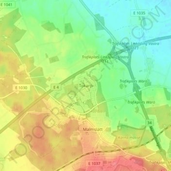
Name: Tokarp topographic map, elevation, terrain.

Location: Tokarp, Linköpings kommun, Östergötland County, 586 62, Sweden (58.40697 15.49381 58.44697 15.53381)

Average elevation: 65 m

Minimum elevation: 37 m

Maximum elevation: 98 m

Other topographic maps

Click on a map to view its topography, its elevation and its terrain.

Kinda kommun

Sweden > Östergötland County

Average elevation: 133 m

Nässja

Sweden > Östergötland County

Average elevation: 91 m

Navestad

Sweden > Östergötland County > Norrköping

Average elevation: 34 m

Vadstena

Sweden > Östergötland County

Average elevation: 98 m

Illern

Sweden > Östergötland County > Linköping

Average elevation: 72 m

Mjölby kommun

Sweden > Östergötland County

Average elevation: 123 m

Halgen

Sweden > Östergötland County

Average elevation: 88 m

Lindö

Sweden > Östergötland County > Lindö

Average elevation: 8 m

Järstad

Sweden > Östergötland County

Average elevation: 82 m

Boxholms kommun

Sweden > Östergötland County

Average elevation: 169 m

Gear up for your next adventure:

🚑Survival Whistle - Signal for help across long distances in mountains
🧥Ultralight Puffy Jacket - Maximum warmth that packs down to the size of an orange
Lightweight Camping Tent - Portable shelter optimized for Canadian backcountry camping
🥾Trail Running Boots - Durable shoes designed for trail running
🛁Quick-Dry Microfiber Towel - Space-saving towel that dries rapidly on the move

As an Amazon Associate, this site earns from qualifying purchases at no extra cost to you.