Geolocate

Balerno topographic map

Click on the map to display elevation.

About this map

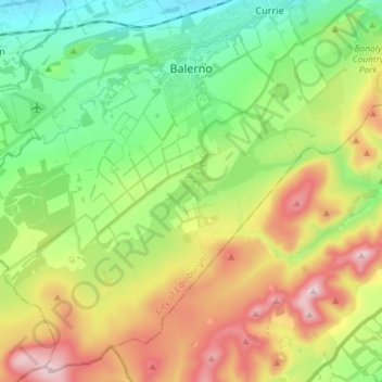
Name: Balerno topographic map, elevation, terrain.

Location: Balerno, City of Edinburgh, Scotland, United Kingdom (55.81879 -3.42014 55.89615 -3.27408)

Average elevation: 287 m

Minimum elevation: 106 m

Maximum elevation: 579 m

Other topographic maps

Click on a map to view its topography, its elevation and its terrain.

Crow Hill

United Kingdom > Scotland > City of Edinburgh

Average elevation: 68 m

Gogarbank

United Kingdom > Scotland > City of Edinburgh

Average elevation: 69 m

Hillend

United Kingdom > Scotland > City of Edinburgh > Ratho

Average elevation: 67 m

Hillend

United Kingdom > Scotland > City of Edinburgh > Ratho

Average elevation: 67 m

Newbridge

United Kingdom > Scotland > City of Edinburgh

Average elevation: 54 m

Gogar

United Kingdom > Scotland > City of Edinburgh

Average elevation: 51 m

Ratho

United Kingdom > Scotland > City of Edinburgh

Average elevation: 80 m

Gear up for your next adventure:

🧢Sun Hat - Wide-brim hat for sun protection
🧥Waterproof Hiking Jacket - Protect yourself from rain and wind while hiking
Camping Groundsheet - Protect your tent from moisture and dirt
🧴Waterproofing Spray - Restore the DWR coating on jackets and tents
Camping Essentials - All-in-one gear for a comfortable camping trip

As an Amazon Associate, this site earns from qualifying purchases at no extra cost to you.