Geolocate

Baruka topographic map

Click on the map to display elevation.

About this map

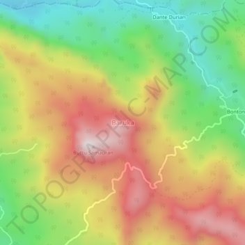
Name: Baruka topographic map, elevation, terrain.

Location: Baruka, Enrekang, South Sulawesi, Sulawesi, Indonesia (-3.55370 119.90387 -3.51370 119.94387)

Average elevation: 851 m

Minimum elevation: 447 m

Maximum elevation: 1,280 m

Other topographic maps

Click on a map to view its topography, its elevation and its terrain.

Baraka

Indonesia > South Sulawesi > Enrekang

Average elevation: 827 m

Malua

Indonesia > South Sulawesi > Enrekang

Average elevation: 709 m

Alla

Indonesia > South Sulawesi > Enrekang

Average elevation: 1,037 m

Bungin

Indonesia > South Sulawesi > Enrekang

Average elevation: 1,238 m

Cendana

Indonesia > South Sulawesi > Enrekang

Average elevation: 152 m

Maiwa

Indonesia > South Sulawesi > Enrekang

Average elevation: 214 m

Malua

Indonesia > South Sulawesi > Enrekang

Average elevation: 709 m

Buntu Batu

Indonesia > South Sulawesi > Enrekang

Average elevation: 1,459 m

Gear up for your next adventure:

🧭Orienteering Kit - Tools for map reading and navigation in the wild
🌡️Emergency Mylar Blankets - Compact thermal protection for unexpected nights outdoors
🔭Compact Binoculars - Lightweight optics for scouting trails and wildlife
🧥Waterproof Pants - Keep dry during rainy hiking conditions
🛏️Camping Sleeping Mat - Comfortable mats for sleeping outdoors

As an Amazon Associate, this site earns from qualifying purchases at no extra cost to you.