Geolocate

Tappahannock topographic map

Click on the map to display elevation.

About this map

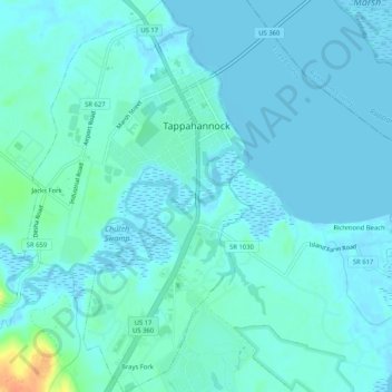
Name: Tappahannock topographic map, elevation, terrain.

Location: Tappahannock, Essex County, Virginia, United States (37.89771 -76.88185 37.93840 -76.85188)

Average elevation: 6 m

Minimum elevation: -2 m

Maximum elevation: 42 m

Other topographic maps

Click on a map to view its topography, its elevation and its terrain.

Caret

United States > Virginia > Essex County

Average elevation: 30 m

Dunnsville

United States > Virginia > Essex County

Average elevation: 21 m

Gear up for your next adventure:

🥾Waterproof Hiking Boots - Essential footwear for rugged terrain and wet Canadian trails
🔦LED Headlamp - Hands-free lighting for early morning starts or late finishes
🧢Hiking Hat - Sun-protective and breathable hats for long treks
🧭GPS Handheld Device - Reliable GPS navigation for outdoor adventures
🧢Beanie Hat - Keep your head warm in cold weather

As an Amazon Associate, this site earns from qualifying purchases at no extra cost to you.