Geolocate

Inzá topographic map

Click on the map to display elevation.

About this map

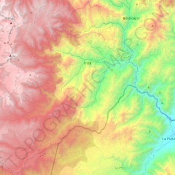
Name: Inzá topographic map, elevation, terrain.

Location: Inzá, Oriente, Cauca, Colombia (2.31691 -76.32846 2.67916 -75.95795)

Average elevation: 2,380 m

Minimum elevation: 971 m

Maximum elevation: 3,836 m

Other topographic maps

Click on a map to view its topography, its elevation and its terrain.

Toscana Circle

Colombia > Cauca > Popayán

Average elevation: 1,735 m

Torres

Colombia > Cauca > La Sierra

Average elevation: 1,759 m

MONDOMO

Colombia > Cauca > Santander de Quilichao

Average elevation: 1,397 m

Rio Negro

Colombia > Cauca > Puracé

Average elevation: 3,199 m

Peña Del Condado

Colombia > Cauca > Silvia > Peña Del Condado

Average elevation: 2,922 m

Páramo de Santo Domingo

Colombia > Cauca > Toribío

Average elevation: 3,886 m

El Condor

Colombia > Cauca > El Condor

Average elevation: 1,950 m

Inzá

Colombia > Cauca > Inzá > Inzá

Average elevation: 1,876 m

Gear up for your next adventure:

🛏️Sleeping Bag - Warm and compact sleeping bags for outdoor camping
🥾Approach Shoes - Shoes designed for climbing approaches and rugged trails
🧥Packable Rain Jacket - Breathable waterproof layer for unpredictable weather
🧣Merino Neck Gaiter - Protects against wind, sun, and cold at high altitudes
🦯Trekking Poles - Reduced impact on joints for steep topographic climbs

As an Amazon Associate, this site earns from qualifying purchases at no extra cost to you.