
Hallandsåsen topographic map
Click on the map to display elevation.
About this map
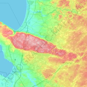
Name: Hallandsåsen topographic map, elevation, terrain.
Location: Hallandsåsen, Skåne County, 286 92, Sweden (56.27828 12.73821 56.46228 13.44829)
Average elevation: 71 m
Minimum elevation: -1 m
Maximum elevation: 222 m
Other topographic maps
Click on a map to view its topography, its elevation and its terrain.
Uppsala
Situated on the fertile Uppsala flatlands of muddy soil, the city features the small Fyris River (Fyrisån) flowing through the landscape surrounded by lush vegetation. Parallel to the river runs the glacial ridge of Uppsalaåsen at an elevation around 30 m (98 ft), the site of Uppsala's castle, from which…
Average elevation: 29 m
Kiruna
Kiruna is located in the north of Sweden, 145 kilometres (90 mi) north of the Arctic circle. The city centre is built on the Haukavaara hill at an altitude of 530 m, high above the Torne river to the north and the Kalix river to the south. Other parts of the town are Lombolo and Tuolluvaara. Near Kiruna are…
Average elevation: 511 m
Örebro
During cold winters, Örebro receives plenty of snowfall. Örebro is far more prone than coastal areas to really harsh frosts with temperatures approaching or below −20 °C (−4 °F) happening almost every winter according to SMHI statistics. The station's setting in a rural location might skew temperatures…
Average elevation: 59 m
Skövde
Sweden > Västra Götaland County
Skövde has a maritime-continental hybrid climate. The town is influenced by being in the slope of a hill, which leads to warmer overnight lows than in Skara on the western side of the same higher area. In July 2018, Skövde recorded a 22 °C (72 °F) mean during the 2018 European heat wave. This makes it one…
Average elevation: 181 m
Jönköping
Jönköping's climate was humid continental (Köppen Dfb) with long, cold winters and short, warm summers during the 1961–1990 period. However, the window between subarctic and oceanic is very small in this marine-influenced climate type, and in recent years the climate has more resembled very cold oceanic.…
Average elevation: 215 m
Sarek
Sarek National Park is the most mountainous region in Sweden and it is the part of the country that mostly resembles an alpine countryside. Within the park are 19 summits higher than 1,900 m (6,200 ft), the most noted being the second highest summit in Sweden after the Kebnekaise – the Sarektjåkkå with a…
Average elevation: 994 m