Geolocate

Sandviken topographic map

Click on the map to display elevation.

About this map

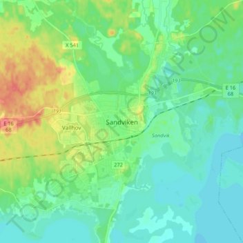
Name: Sandviken topographic map, elevation, terrain.

Location: Sandviken, Sandvikens kommun, Gävleborg County, 811 39, Sweden (60.58187 16.73600 60.66187 16.81600)

Average elevation: 73 m

Minimum elevation: 56 m

Maximum elevation: 116 m

Other topographic maps

Click on a map to view its topography, its elevation and its terrain.

Gävle

Sweden > Gävleborg County

Average elevation: 28 m

Disan

Sweden > Gävleborg County

Average elevation: 43 m

Gran

Sweden > Gävleborg County > Gnarp District

Average elevation: 0 m

Ljusdals kommun

Sweden > Gävleborg County

Average elevation: 315 m

Hamra

Sweden > Gävleborg County

Average elevation: 437 m

Hamra

Sweden > Gävleborg County

Average elevation: 437 m

Hudiksvalls kommun

Sweden > Gävleborg County

Average elevation: 95 m

Hamra

Sweden > Gävleborg County

Average elevation: 437 m

Söderhamns kommun

Sweden > Gävleborg County

Average elevation: 67 m

Gnarp District

Sweden > Gävleborg County

Average elevation: 32 m

Gävle kommun

Sweden > Gävleborg County

Average elevation: 61 m

Ovanåkers kommun

Sweden > Gävleborg County

Average elevation: 269 m

Hofors kommun

Sweden > Gävleborg County

Average elevation: 147 m

Gear up for your next adventure:

🧭GPS Tracker - Track your location in remote areas safely
🧦Outdoor Socks - Durable socks designed for hiking and outdoor sports
🛰️Satellite Messenger - Emergency communication for areas with no cell service
🎒Hiking Backpack - Lightweight and ergonomic backpacks for day hikes or multi-day treks
🧴Waterproofing Spray - Restore the DWR coating on jackets and tents

As an Amazon Associate, this site earns from qualifying purchases at no extra cost to you.