Geolocate

Peoria topographic map

Click on the map to display elevation.

About this map

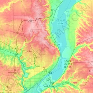
Name: Peoria topographic map, elevation, terrain.

Location: Peoria, Peoria County, Illinois, United States (40.65194 -89.69887 40.84412 -89.54649)

Average elevation: 189 m

Minimum elevation: 130 m

Maximum elevation: 251 m

Other topographic maps

Click on a map to view its topography, its elevation and its terrain.

Monica

United States > Illinois > Peoria County

Average elevation: 230 m

Kickapoo

United States > Illinois > Peoria County

Average elevation: 198 m

Trivoli

United States > Illinois > Peoria County

Average elevation: 224 m

Peoria

United States > Illinois > Peoria County > Peoria

Average elevation: 196 m

Gear up for your next adventure:

🧰Multitool Knife - Compact and versatile tool for outdoor use
🦶Hiking Shoe Insoles - Added support for high arches and long days on feet
🔨Vehicle Emergency Tool - Safety tool for remote road trips to trailheads
🕶️Polarized Sunglasses - Reduces glare from snow and water at high elevations
🧭GPS Outdoor Watch - Smart watch for navigation and fitness tracking in nature

As an Amazon Associate, this site earns from qualifying purchases at no extra cost to you.