Geolocate

Barton topographic map

Click on the map to display elevation.

About this map

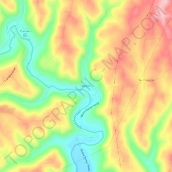
Name: Barton topographic map, elevation, terrain.

Location: Barton, Belmont County, Ohio, 43905, United States (40.08729 -80.86120 40.12729 -80.82120)

Average elevation: 315 m

Minimum elevation: 225 m

Maximum elevation: 399 m

Other topographic maps

Click on a map to view its topography, its elevation and its terrain.

Martins Ferry

United States > Ohio > Belmont County

Average elevation: 288 m

Brookside

United States > Ohio > Belmont County

Average elevation: 281 m

Neffs

United States > Ohio > Belmont County > Neffs

Average elevation: 300 m

Morristown

United States > Ohio > Belmont County

Average elevation: 374 m

Flushing

United States > Ohio > Belmont County

Average elevation: 365 m

Holloway

United States > Ohio > Belmont County

Average elevation: 313 m

Bridgeport

United States > Ohio > Belmont County

Average elevation: 244 m

Bethesda

United States > Ohio > Belmont County

Average elevation: 376 m

Belmont

United States > Ohio > Belmont County

Average elevation: 361 m

Piedmont Lake

United States > Ohio > Belmont County

Average elevation: 321 m

Yorkville

United States > Ohio > Belmont County

Average elevation: 256 m

Powhatan Point

United States > Ohio > Belmont County

Average elevation: 241 m

Shadyside

United States > Ohio > Belmont County

Average elevation: 245 m

Gear up for your next adventure:

💧Reusable Water Bottle - Durable water bottles for hydration on trails
Camping Coffee Maker - Brew fresh coffee anywhere on the topographic map
🛰️Satellite Messenger - Emergency communication for areas with no cell service
🧥Thermal Layer - Insulating layer for cold outdoor conditions
🧭GPS Tracker - Track your location in remote areas safely

As an Amazon Associate, this site earns from qualifying purchases at no extra cost to you.