Manipur topographic map
Click on the map to display elevation.
Manipur
The state lies at a latitude of 23°83'N – 25°68'N and a longitude of 93°03'E – 94°78'E. The total area covered by the state is 22,327 km2 (8,621 sq mi). The capital lies in an oval-shaped valley of approximately 700 sq mi (2,000 km2), surrounded by blue mountains, at an elevation of 790 m (2,590 ft) above sea level. The slope of the valley is from north to south. The mountain ranges create a moderate climate, preventing the cold winds from the north from reaching the valley and barring cyclonic storms.
About this map
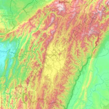
Name: Manipur topographic map, elevation, terrain.
Location: Manipur, India (23.83362 92.97071 25.69210 94.74524)
Average elevation: 810 m
Minimum elevation: 19 m
Maximum elevation: 2,997 m
Other topographic maps
Click on a map to view its topography, its elevation and its terrain.
Western Ghats
The range starts near south of the Tapti river and runs approximately 1,600 km (990 mi) through the states of Gujarat, Maharashtra, Karnataka, Goa, Kerala and Tamil Nadu ending at Marunthuvazh Malai, Swamithope near the southern tip of India. These hills cover 160,000 km2 (62,000 sq mi) and form the catchment…
Average elevation: 2,225 m
Haldia
India > West Bengal > Haldia
Haldia is located at 22°02′N 88°04′E / 22.03°N 88.06°E / 22.03; 88.06. It has an average elevation of 8 metres (26 ft).
Average elevation: 3 m

Maharashtra
Maharashtra is the third largest state by area in India. The Western Ghats better known as Sahyadri, are a hilly range running parallel to the coast, at an average elevation of 1,200 metres (4,000 ft). Kalsubai, a peak in the Sahyadris, near Nashik city is the highest elevated point in Maharashtra. To the west…
Average elevation: 478 m
Lucknow
India > Uttar Pradesh > Lucknow
Lucknow stands at an elevation of approximately 123 metres (404 ft) above sea level. The city had an area of 402 km2 (155 square miles) until December 2019, when 88 villages were added to the municipal limits and the area increased to 631 km2 (244 square miles). Bounded on the east by Barabanki, on the west by…
Average elevation: 120 m

Bengaluru
India > Karnataka > Bangalore North
Bengaluru lies in the southeast of the South Indian state of Karnataka in the heart of the Mysore Plateau (a region of the larger Deccan Plateau) at an average elevation of 900 m (2,953 ft). The city covers an area of 741 km2 (286 sq mi). The Bengaluru metropolitan region covers an area of 7,005 km2 (2,705 sq…
Average elevation: 879 m
Pithoragarh
India > Uttarakhand > Pithoragarh Tehsil
Pithoragarh is located at 29°35′N 80°13′E / 29.58°N 80.22°E / 29.58; 80.22. in the district of Pithoragarh, Uttarakhand, India. It lies in the revenue Division of Kumaon and is located 188 km northeast of Nainital, the administrative headquarters of Kumaon. It has an average elevation of 1,627…
Average elevation: 1,617 m
Shimla
Shimla is on the south-western ranges of the Himalayas at 31°37′N 77°06′E / 31.61°N 77.10°E / 31.61; 77.10. It has an average altitude of 2,206 metres (7,238 ft) above mean sea level and extends along a ridge with seven spurs. The city stretches nearly 9.2 kilometres (5.7 mi) from east to west.
Average elevation: 1,557 m
Mumbai
Mumbai lies at the mouth of the Ulhas River on the western coast of India, in the coastal region known as the Konkan. It sits on Salsette Island (Sashti Island), which it partially shares with the Thane district. Mumbai is bounded by the Arabian Sea to the west. Many parts of the city lie just above sea level,…
Average elevation: 13 m
Dakshina Kannada
The topography of the district is plain up to 30 km (18.64 mi) inside the coast and changes to undulating hilly terrain sharply towards the east in the Western Ghats. Teak, bamboo and rosewood trees are found in the hilly areas towards the east. The Geological Survey of India has identified this district as a…
Average elevation: 109 m

Kolkata
Spread roughly north–south along the east bank of the Hooghly River, Kolkata sits within the lower Ganges Delta of eastern India approximately 75 km (47 mi) west of the international border with Bangladesh; the city's elevation is 1.5–9 m (5–30 ft). Much of the city was originally a wetland that was…
Average elevation: 5 m











Gurudongmar
India > Sikkim > Chungthang
Gurudongmar Lake is one of the highest lakes in the world and in India, at an elevation of 5,430 m (17,800 ft) according to the Government of Sikkim. It is located in the Great Himalayas in the Mangan District in Indian state of Sikkim, and considered sacred by Buddhists and Sikhs. The lake is named after…
Average elevation: 5,232 m
Lansdowne
India > Uttarakhand > Lansdowne
Lansdowne is a quaint hill station in the Pauri Garhwal district of Uttarakhand, India. Lodged in the picturesque surroundings of the Himalayan ranges, it lies at an elevation of approximately 1,700 meters (5,577 feet) above sea level. The town is about 45 kilometers (28 miles) from the district headquarters,…
Average elevation: 1,140 m


Kakdwip
India > West Bengal > Kakdwip
Kakdwip is located at 21°52′45″N 88°11′29″E / 21.8791446°N 88.1912992°E / 21.8791446; 88.1912992. It has an average elevation of 4 metres (13 ft).
Average elevation: 3 m

Kodaikanal
India > Tamil Nadu > Kodaikanal
Kodaikanal has a monsoon-influenced subtropical highland climate (Cfb, according to the Köppen climate classification, with a Cwb tendency). The temperatures are cool throughout the year due to the high elevation of the city.
Average elevation: 1,958 m


Chennai
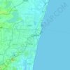
Chennai is located on the south–eastern coast of India in the north–eastern part of Tamil Nadu on a flat coastal plain known as the Eastern Coastal Plains. Its average elevation is around 6.7 metres (22 ft), and its highest point is 60 m (200 ft). Chennai is 2,184 kilometres (1,357 mi) south of Delhi,…
Average elevation: 7 m


Mysuru
India > Karnataka > Mysuru taluk
Mysore (/maɪˈsɔːr/ (listen)), officially Mysuru ([ˈmaɪˈsuːɾu] (listen)), is a city in the southern part of the state of Karnataka, India. Mysore city is geographically located between 12° 18′ 26″ north latitude and 76° 38′ 59″ east longitude. It is located at an altitude of 770 m (2,530 ft)…
Average elevation: 727 m
Mangaluru
India > Karnataka > Mangaluru taluk
Mangalore is also the administrative headquarters of the Dakshina Kannada district; it is a commercial, industrial, educational, healthcare, and startup hub. The city's international airport is the second-largest and second-busiest airport in Karnataka. Mangalore City Corporation is responsible for the civic…
Average elevation: 25 m
Ranchi
Ranchi lies at 23°22′N 85°20′E / 23.36°N 85.33°E / 23.36; 85.33 near to the Tropic of Cancer. The city covers an area of 175 km2 (68 sq mi) and its average elevation is 651 m above sea level. Ranchi is located in the southern part of the Chota Nagpur plateau, which is the eastern section of…
Average elevation: 648 m
Varanasi
India > Uttar Pradesh > Sadar
Varanasi is located at an elevation of 80.71 metres (264.8 ft) in the centre of the Ganges valley of North India, in the Eastern part of the state of Uttar Pradesh, along the left crescent-shaped bank of the Ganges, averaging between 15 metres (50 ft) and 21 metres (70 ft) above the river. The city is the…
Average elevation: 77 m
Kadapa
India > Andhra Pradesh > Kadapa
Kadapa in the Rayalaseema region of Andhra Pradesh is located at 14°28′N 78°49′E / 14.47°N 78.82°E / 14.47; 78.82 about 412 km from Hyderabad, 260 km from Chennai, 250 km from Bangalore and 360 km from Vijayawada. The city is situated in the Bugga vanka or Ralla Vanka rivers bordered by the…
Average elevation: 257 m