Geolocate

Milton topographic map

Click on the map to display elevation.

About this map

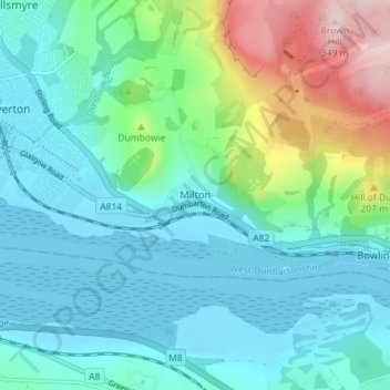
Name: Milton topographic map, elevation, terrain.

Location: Milton, West Dunbartonshire, Scotland, G82 2TR, United Kingdom (55.91706 -4.53901 55.95706 -4.49901)

Average elevation: 78 m

Minimum elevation: -3 m

Maximum elevation: 352 m

Other topographic maps

Click on a map to view its topography, its elevation and its terrain.

Gear up for your next adventure:

🥾Light Hiking Boots - Lightweight and comfortable boots for day hikes
🧴Bear Spray Holster - Quick-access carry for essential Canadian wilderness safety
🧢Hiking Sun Hat - Wide-brimmed protection for exposed mountain ridges
🕶️Polarized Sunglasses - Reduces glare from snow and water at high elevations
💧Hydration Bladder - Hands-free hydration solution for long treks

As an Amazon Associate, this site earns from qualifying purchases at no extra cost to you.