
Moreton-in-Marsh topographic map
Click on the map to display elevation.
About this map
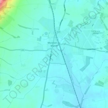
Name: Moreton-in-Marsh topographic map, elevation, terrain.
Average elevation: 135 m
Minimum elevation: 120 m
Maximum elevation: 230 m
Other topographic maps
Click on a map to view its topography, its elevation and its terrain.
Winstone
United Kingdom > England > Gloucestershire > Cotswold District > Winstone
Average elevation: 222 m
Duntisbourne Abbots
United Kingdom > England > Gloucestershire > Cotswold District
Average elevation: 204 m
Stow-on-the-Wold
United Kingdom > England > Gloucestershire > Cotswold District
Average elevation: 163 m
Lower Slaughter
United Kingdom > England > Gloucestershire > Cotswold District
Average elevation: 160 m
Calcot
United Kingdom > England > Gloucestershire > Cotswold District > Coln Rogers
Average elevation: 151 m
Caudle Green
United Kingdom > England > Gloucestershire > Cotswold District > Brimpsfield
Average elevation: 234 m
Bourton-on-the-Hill
United Kingdom > England > Gloucestershire > Cotswold District
Average elevation: 196 m
Hidcote Bartrim
United Kingdom > England > Gloucestershire > Cotswold District > Ebrington
Average elevation: 148 m
Bushley Muzzard, Brimpsfield
United Kingdom > England > Gloucestershire > Cotswold District > Nettleton > Watercombe
Average elevation: 261 m
Upper Oddington
United Kingdom > England > Gloucestershire > Cotswold District
Average elevation: 134 m
Weston-sub-Edge
United Kingdom > England > Gloucestershire > Cotswold District
Average elevation: 98 m
Knap House Quarry, Birdlip
United Kingdom > England > Gloucestershire > Cotswold District > Birdlip
Average elevation: 222 m
Botany Bay Wood
United Kingdom > England > Gloucestershire > Cotswold District > Stow-on-the-Wold
Average elevation: 171 m
Trewsbury Mead
United Kingdom > England > Gloucestershire > Cotswold District
Average elevation: 122 m
Shipton Oliffe
United Kingdom > England > Gloucestershire > Cotswold District > Shipton
Average elevation: 201 m
Seven Springs
United Kingdom > England > Gloucestershire > Cotswold District > Coberley
Average elevation: 236 m
Nags Head
United Kingdom > England > Gloucestershire > Cotswold District > Avening
Average elevation: 155 m
Ablington
United Kingdom > England > Gloucestershire > Cotswold District > Ablington
Average elevation: 136 m
Paxford
United Kingdom > England > Gloucestershire > Cotswold District > Paxford
Average elevation: 124 m
Compton Abdale
United Kingdom > England > Gloucestershire > Cotswold District
Average elevation: 212 m
Eastleach Martin
United Kingdom > England > Gloucestershire > Cotswold District > Eastleach Turville
Average elevation: 111 m
Somerford Keynes
United Kingdom > England > Gloucestershire > Cotswold District
Average elevation: 91 m
Bledington
United Kingdom > England > Gloucestershire > Cotswold District > Bledington
Average elevation: 118 m