
District Municipality of Muskoka topographic map
Interactive map
Click on the map to display elevation.
About this map
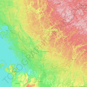
Name: District Municipality of Muskoka topographic map, elevation, terrain.
Average elevation: 298 m
Minimum elevation: 172 m
Maximum elevation: 555 m
Muskoka District trails, hiking, mountain biking, running and outdoor activities
Other topographic maps
Click on a map to view its topography, its elevation and its terrain.
Limberlost Forest and Wildlife Reserve
Canada > Ontario > Muskoka District > Lake of Bays Township
Average elevation: 400 m
Old Big Chute Marine Railway
Canada > Ontario > Muskoka District > Georgian Bay Township
Average elevation: 198 m
Beausoleil Island
Canada > Ontario > Muskoka District > Georgian Bay Township
Average elevation: 180 m