
Gray Island topographic map
Click on the map to display elevation.
About this map
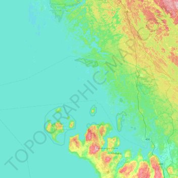
Name: Gray Island topographic map, elevation, terrain.
Average elevation: 196 m
Minimum elevation: 171 m
Maximum elevation: 328 m
Muskoka District trails, hiking, mountain biking, running and outdoor activities
Other topographic maps
Click on a map to view its topography, its elevation and its terrain.
Georgian Bay Islands National Park
Canada > Ontario > Muskoka District > Georgian Bay Township
Average elevation: 182 m
Stewart Lake
Canada > Ontario > Muskoka District > Georgian Bay Township > MacTier
Average elevation: 241 m
Old Big Chute Marine Railway
Canada > Ontario > Muskoka District > Georgian Bay Township
Average elevation: 198 m