
Turin topographic map
Interactive map
Click on the map to display elevation.
About this map
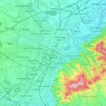
Name: Turin topographic map, elevation, terrain.
Location: Turin, Torino, Piedmont, Italy (45.00679 7.57783 45.14022 7.77334)
Average elevation: 289 m
Minimum elevation: 193 m
Maximum elevation: 713 m
Other topographic maps
Click on a map to view its topography, its elevation and its terrain.
Li Rochette
Italy > Piedmont > Torino > Caselette
Li Rochette, Caselette, Torino, Piedmont, Italy
Average elevation: 530 m
Sant'Antonino di Susa
Sant'Antonino di Susa, Torino, Piedmont, Italy
Average elevation: 798 m