
Aksu City topographic map
Interactive map
Click on the map to display elevation.
About this map
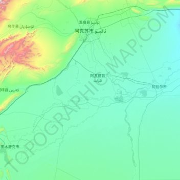
Name: Aksu City topographic map, elevation, terrain.
Location: Aksu City, Aksu Prefecture, Xinjiang, China (39.48232 79.71869 41.50247 82.00710)
Average elevation: 1,188 m
Minimum elevation: 991 m
Maximum elevation: 4,210 m
Other topographic maps
Click on a map to view its topography, its elevation and its terrain.
Karamay
Karamay is located in the northwest of the Dzungarian basin, with an average elevation of 400 meters (1,300 ft). Its administrative area ranges in latitude from 44° 07' to 46° 08' N and in longitude from 80° 44' to 86° 01' E, and has a maximal 240 km (150 mi) north-south extent and reaches 110 km (68 mi)…
Average elevation: 510 m
Tian Shan
Continuous permafrost is typically found in the Tian Shan starting at the elevation of about 3,500-3,700 m above the sea level. Discontinuous alpine permafrost usually occurs down to 2,700-3,300 m, but in certain locations, due to the peculiarity of the aspect and the microclimate, it can be found at…
Average elevation: 6,096 m