
Bilbao topographic map
Interactive map
Click on the map to display elevation.
About this map
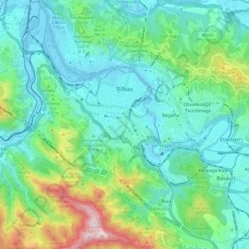
Name: Bilbao topographic map, elevation, terrain.
Average elevation: 156 m
Minimum elevation: -2 m
Maximum elevation: 674 m
Bilbao is located in the north-central part of Spain, some 16 kilometres (10 mi) south of the Bay of Biscay, where the economic social development is located, where the estuary of Bilbao is formed. Its main urban core is surrounded by two small mountain ranges with an average elevation of 400 metres (1,300 ft). Its climate is shaped by the Bay of Biscay low-pressure systems and mild air, moderating summer temperatures by Iberian standards, with low sunshine and high rainfall. The annual temperature range is low for its latitude.
Other topographic maps
Click on a map to view its topography, its elevation and its terrain.
Ibarra
Spain > Autonomous Community of the Basque Country
Ibarra, Gipuzkoa, Autonomous Community of the Basque Country, 20400, Spain
Average elevation: 259 m
Bidasoa Beherea / Bajo Bidasoa
Spain > Autonomous Community of the Basque Country
Bidasoa Beherea / Bajo Bidasoa, Gipuzkoa, Autonomous Community of the Basque Country, Spain
Average elevation: 111 m
Arrutiegia
Spain > Autonomous Community of the Basque Country > Urola-Kosta > Aia
Arrutiegia, Aia, Urola-Kosta, Gipuzkoa, Autonomous Community of the Basque Country, 20809, Spain
Average elevation: 223 m
Donostia / San Sebastián
Spain > Autonomous Community of the Basque Country > Donostialdea > Donostia / San Sebastián
Donostia / San Sebastián, San Sebastián, Donostialdea, Gipuzkoa, Autonomous Community of the Basque Country, 20003, Spain
Average elevation: 134 m
Hondarribia/Fontarrabie
Spain > Autonomous Community of the Basque Country > Bidasoa Beherea / Bajo Bidasoa
Hondarribia/Fontarrabie, Bidasoa Beherea / Bajo Bidasoa, Gipuzkoa, Autonomous Community of the Basque Country, 20280, Spain
Average elevation: 37 m
Mañuas
Spain > Autonomous Community of the Basque Country > Bermeo
Mañuas, Bilbao - Bermeo errepidea, Mañu Arranotegi, Bermeo, Biscay, Autonomous Community of the Basque Country, 48370, Spain
Average elevation: 289 m
Gipuzkoa
Spain > Autonomous Community of the Basque Country
Gipuzkoa, Autonomous Community of the Basque Country, Spain
Average elevation: 396 m
Bilbao
Spain > Autonomous Community of the Basque Country > Bilbao
Bilbao, Greater Bilbao, Biscay, Autonomous Community of the Basque Country, Spain
Average elevation: 156 m
Soil
Spain > Autonomous Community of the Basque Country > Montaña Alavesa/Arabako Mendialdea
Soil, Arraia-Maeztu, Montaña Alavesa/Arabako Mendialdea, Álava, Autonomous Community of the Basque Country, 01207, Spain
Average elevation: 898 m
Biscay
Spain > Autonomous Community of the Basque Country
Biscay, Autonomous Community of the Basque Country, Spain
Average elevation: 333 m
Vitoria-Gasteiz
Spain > Autonomous Community of the Basque Country > Gasteizko kuadrilla/Cuadrilla de Vitoria
Vitoria-Gasteiz, Gasteizko kuadrilla/Cuadrilla de Vitoria, Álava, Autonomous Community of the Basque Country, Spain
Average elevation: 626 m
Getaria
Spain > Autonomous Community of the Basque Country > Getaria
Getaria, Urola-Kosta, Gipuzkoa, Autonomous Community of the Basque Country, 20808, Spain
Average elevation: 75 m
Elvillar/Bilar
Spain > Autonomous Community of the Basque Country > Elvillar/Bilar
Elvillar/Bilar, Arabako Errioxa/Rioja Alavesa, Álava, Autonomous Community of the Basque Country, Spain
Average elevation: 561 m