Geolocate

Coburg topographic map

Interactive map

Click on the map to display elevation.

About this map

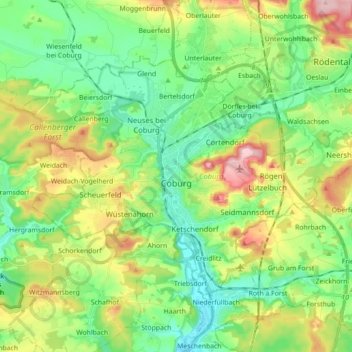
Name: Coburg topographic map, elevation, terrain.

Location: Coburg, Bavaria, 96450, Germany (50.22175 10.88726 50.29891 11.06376)

Average elevation: 339 m

Minimum elevation: 275 m

Maximum elevation: 462 m

Other topographic maps

Click on a map to view its topography, its elevation and its terrain.

Allgäu

Germany > Bavaria

Average elevation: 1,087 m

Irsengund

Germany > Bavaria > Landkreis Lindau

Average elevation: 837 m

Stalling

Germany > Bavaria > Landkreis Traunstein > Palling

Average elevation: 543 m

Inn

Germany > Bavaria > Landkreis Rosenheim > Wasserburg am Inn

Average elevation: 464 m

Gögglbach

Germany > Bavaria > Landkreis Schwandorf > Schwandorf

Average elevation: 395 m

Rubi

Germany > Bavaria > Landkreis Oberallgäu > Oberstdorf

Average elevation: 973 m

Wind

Germany > Bavaria > Landkreis Bamberg

Average elevation: 284 m

Horn

Germany > Bavaria > Ansbach (district) > Leutershausen

Average elevation: 471 m

Neuburg-Schrobenhausen

Germany > Bavaria

Average elevation: 483 m

Gänheim

Germany > Bavaria > Landkreis Main-Spessart > Arnstein > Gänheim

Average elevation: 265 m

Ingolstadt

Germany > Bavaria > Ingolstadt > Ingolstadt

Average elevation: 409 m

Ansbach

Germany > Bavaria > Ansbach

Average elevation: 448 m

Fraueninsel

Germany > Bavaria > Chiemsee

Average elevation: 518 m

Drei Zinnen

Germany > Bavaria > Hiltpoltstein

Average elevation: 463 m

Rohrbach

Germany > Bavaria > Happurg

Average elevation: 486 m

Horn

Germany > Bavaria > Leutershausen

Average elevation: 474 m

Braun

Germany > Bavaria > Lappach > Braun

Average elevation: 558 m

Neukirchen

Germany > Bavaria > Eglharting > Neukirchen

Average elevation: 559 m