
Rockland County topographic map
Interactive map
Click on the map to display elevation.
About this map
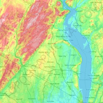
Name: Rockland County topographic map, elevation, terrain.
Location: Rockland County, New York, United States (40.99717 -74.23435 41.32493 -73.88665)
Average elevation: 138 m
Minimum elevation: 0 m
Maximum elevation: 424 m
Other topographic maps
Click on a map to view its topography, its elevation and its terrain.
Roundtop Mountain
United States > New York > Ulster County > Town of Woodstock
Average elevation: 505 m
Center Island
United States > New York > Albany County > Town of Colonie > Village of Green Island
Average elevation: 24 m
Stanley Manor
United States > New York > Onondaga County > Fairmount > Town of Camillus
Average elevation: 189 m
Salisbury Meadow
United States > New York > Rockland County > Town of Stony Point
Average elevation: 97 m
Niagara Escarpment
United States > New York > Niagara County > City of Lockport
Average elevation: 165 m
Black Rock Mountain
United States > New York > Orange County > Town of Tuxedo
Average elevation: 330 m
Heath Ridge
United States > New York > Westchester County > Village of Scarsdale
Average elevation: 66 m
Wilmot Woods
United States > New York > Westchester County > City of New Rochelle
Average elevation: 70 m
Canoe Place
United States > New York > Suffolk County > Hampton Bays > Town of Southampton
Average elevation: 10 m
Black Creek Village
United States > New York > Niagara County > City of Niagara Falls
Average elevation: 176 m
Forest Knolls
United States > New York > Westchester County > City of New Rochelle
Average elevation: 34 m
Carpenter Hill
United States > New York > Hamilton County > Town of Lake Pleasant
Average elevation: 554 m
Oscawana Corners
United States > New York > Putnam County > Town of Putnam Valley
Average elevation: 158 m
Sister Island
United States > New York > Saint Lawrence County > Town of Hammond
Average elevation: 113 m
Height of Land Mountain
United States > New York > Warren County > Town of Johnsburg
Average elevation: 759 m
Cross River
United States > New York > Westchester County > Town of Lewisboro
Average elevation: 155 m
Gilbert Corners
United States > New York > Putnam County > Town of Putnam Valley
Average elevation: 193 m
Singer Castle
United States > New York > Saint Lawrence County > Town of Hammond
Average elevation: 73 m
Three Sisters Mountain
United States > New York > Hamilton County > Town of Arietta
Average elevation: 537 m
Clinton Heights
United States > New York > Rensselaer County > Town of East Greenbush
Average elevation: 49 m
Diamond Point (hamlet)
United States > New York > Warren County > Town of Lake George
Average elevation: 191 m
Lewiston Heights
United States > New York > Niagara County > Town of Lewiston > Village of Lewiston
Average elevation: 144 m
Central Park
United States > New York > New York County > New York
In June 1856, Fernando Wood appointed a "consulting board" of seven people, headed by author Washington Irving, to inspire public confidence in the proposed development. Wood hired military engineer Egbert Ludovicus Viele as the park's chief engineer, tasking him with a topographical survey of the site. The…
Average elevation: 26 m
Elka Park
United States > New York > Greene County > Town of Hunter > Elka Park
Average elevation: 729 m
Waterport
United States > New York > Orleans County > Town of Carlton > Waterport
Average elevation: 107 m
Beechmont
United States > New York > Westchester County > City of New Rochelle > Beechmont
Average elevation: 31 m
Parkside
United States > New York > Westchester County > City of Mount Vernon > Parkside
Average elevation: 27 m