
Treadwell topographic map
Interactive map
Click on the map to display elevation.
About this map
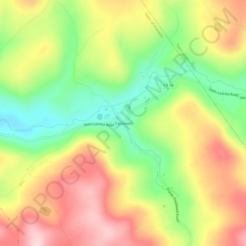
Name: Treadwell topographic map, elevation, terrain.
Average elevation: 558 m
Minimum elevation: 430 m
Maximum elevation: 686 m
Other topographic maps
Click on a map to view its topography, its elevation and its terrain.
Town of Andes
United States > New York > Delaware County
Town of Andes, Delaware County, New York, 13731, United States
Average elevation: 615 m
Town of Hancock
United States > New York > Delaware County
Town of Hancock, Delaware County, New York, United States
Average elevation: 476 m
Town of Middletown
United States > New York > Delaware County
Town of Middletown, Delaware County, New York, United States
Average elevation: 667 m
Bovina Center
United States > New York > Delaware County
Bovina Center, Town of Bovina, Delaware County, New York, 13740, United States
Average elevation: 600 m