
Waskesiu Lake topographic map
Interactive map
Click on the map to display elevation.
About this map
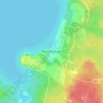
Name: Waskesiu Lake topographic map, elevation, terrain.
Location: Waskesiu Lake, Saskatchewan, S0J 2Y0, Canada (53.90214 -106.10361 53.94214 -106.06361)
Average elevation: 549 m
Minimum elevation: 529 m
Maximum elevation: 600 m
Saskatchewan trails, hiking, mountain biking, running and outdoor activities
Other topographic maps
Click on a map to view its topography, its elevation and its terrain.
Regina
Unlike other planned cities in the Canadian West, on its treeless flat plain Regina has few topographical features other than the small spring run-off, Wascana Creek. Early planners took advantage of such opportunity by damming the creek to create a decorative lake to the south of the central business district…
Average elevation: 582 m
Saskatoon
Saskatoon lies on a long belt of rich, potassic chernozem in middle-southern Saskatchewan and is found in the aspen parkland biome. The lack of surrounding mountainous topography gives the city a relatively flat grid, though the city does sprawl over a few hills and into a few valleys. The lowest point in the…
Average elevation: 504 m
Buffalo Pound Lake
Canada > Saskatchewan > Marquis No. 191 > South Lake
Buffalo Pound Lake is a eutrophic prairie lake formed from glacial melt about 10,000 years ago on the Qu'Appelle River in Saskatchewan, Canada. It is located approximately 28 kilometres (17 mi) north of Moose Jaw and 11 kilometres (6.8 mi) north-east of Tuxford. The lake gets its name from the method used by…
Average elevation: 581 m
Cree Lake
Canada > Saskatchewan > Unorganized Division No. 18
Cree Lake is the remnant of a much larger proglacial lake. The proglacial lake was formed by the meltwaters of retreating continental glaciers during the last ice age about 8,700 years ago. This proglacial lake flowed south into the Churchill River drainage basin via glacial spillways. After the retreat of the…
Average elevation: 508 m
Primrose Lake
Canada > Saskatchewan > Unorganized Division No. 18
Primrose Lake has a total surface area of 444 km2 (171 sq mi), 17.7 km2 (6.8 sq mi) of which is in Alberta, and an elevation of 559 metres (1,834 ft). It lies within muskeg and the boreal forest ecozone of Canada. There are several rivers and creeks that flow into the lake with Calder River on the northern…
Average elevation: 607 m
Mosquito, Grizzly Bear's Head, Lean Man TLE 1
Canada > Saskatchewan > Mullingar
Average elevation: 604 m
North Saskatchewan River
Canada > Saskatchewan > Battle River No. 438 > Prince Albert
Average elevation: 610 m
Saskatoon
Saskatoon lies on a long belt of rich, potassic chernozem in middle-southern Saskatchewan and is found in the aspen parkland biome. The lack of surrounding mountainous topography gives the city a relatively flat grid, though the city does sprawl over a few hills and into a few valleys. The lowest point in the…
Average elevation: 504 m
Regina
Unlike other planned cities in the Canadian West, on its treeless flat plain Regina has few topographical features other than the small spring run-off, Wascana Creek. Early planners took advantage of such opportunity by damming the creek to create a decorative lake to the south of the central business district…
Average elevation: 582 m
Saskatoon
Saskatoon lies on a long belt of rich, potassic chernozem in middle-southern Saskatchewan and is found in the aspen parkland biome. The lack of surrounding mountainous topography gives the city a relatively flat grid, though the city does sprawl over a few hills and into a few valleys. The lowest point in the…
Average elevation: 504 m