
Scarborough topographic map
Interactive map
Click on the map to display elevation.
Scarborough
The climate is temperate with mild summers and cool, windy, winters. The hottest months of the year are July and August, with temperatures reaching an average high of 17 °C and falling to 11 °C at night. The average daytime temperatures in January are 4 °C, falling to 1 °C at night. The station's elevation of 110 metres (360 ft) is far above sea level compared to the immediate coastline, where the climate is likely slightly milder year round.
About this map
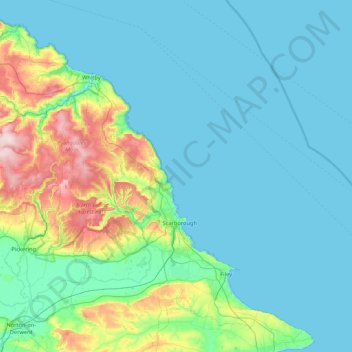
Name: Scarborough topographic map, elevation, terrain.
Location: Scarborough, North Yorkshire, England, United Kingdom (54.13242 -1.06468 54.56214 -0.21235)
Average elevation: 50 m
Minimum elevation: 0 m
Maximum elevation: 323 m
Other topographic maps
Click on a map to view its topography, its elevation and its terrain.
Harrogate
United Kingdom > England > North Yorkshire
Harrogate is situated on the edge of the Yorkshire Dales, with the Vale of York to the east and the upland Yorkshire Dales to the west and north-west. It has a dry and mild climate, typical of places in the rain shadow of the Pennines. It is on the A59 from Skipton to York. At an altitude of between 100 and…
Average elevation: 106 m