
Thank you for supporting this site ❤️
Make a donation
Make a donation
Gear up for your next adventure:
As an Amazon Associate, this site earns from qualifying purchases at no extra cost to you.
Drumheller topographic map
Click on the map to display elevation.
Thank you for supporting this site ❤️
Make a donation
Make a donation
Gear up for your next adventure:
As an Amazon Associate, this site earns from qualifying purchases at no extra cost to you.
About this map
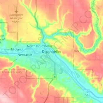
Name: Drumheller topographic map, elevation, terrain.
Location: Drumheller, Alberta, T0J 0Y2, Canada (51.42628 -112.74466 51.50628 -112.66466)
Average elevation: 763 m
Minimum elevation: 675 m
Maximum elevation: 858 m
Drumheller trails, hiking, mountain biking, running and outdoor activities
Thank you for supporting this site ❤️
Make a donation
Make a donation
Gear up for your next adventure:
As an Amazon Associate, this site earns from qualifying purchases at no extra cost to you.