
Make a donation
Gear up for your next adventure:
As an Amazon Associate, this site earns from qualifying purchases at no extra cost to you.
Sainte-Adèle topographic map
Click on the map to display elevation.
Make a donation
Gear up for your next adventure:
As an Amazon Associate, this site earns from qualifying purchases at no extra cost to you.
About this map
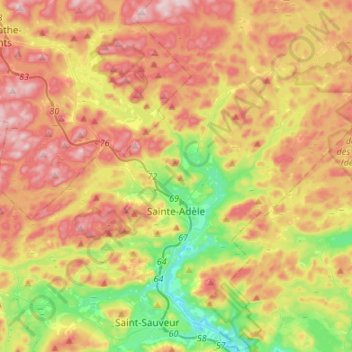
Name: Sainte-Adèle topographic map, elevation, terrain.
Average elevation: 336 m
Minimum elevation: 155 m
Maximum elevation: 526 m
Les Pays-d'en-Haut trails, hiking, mountain biking, running and outdoor activities
Make a donation
Gear up for your next adventure:
As an Amazon Associate, this site earns from qualifying purchases at no extra cost to you.
Other topographic maps
Click on a map to view its topography, its elevation and its terrain.
Saint-Michel-de-Wentworth
Canada > Quebec > Les Pays-d'en-Haut > Wentworth-Nord
Average elevation: 320 m
Make a donation
Gear up for your next adventure:
As an Amazon Associate, this site earns from qualifying purchases at no extra cost to you.
Make a donation
Gear up for your next adventure:
As an Amazon Associate, this site earns from qualifying purchases at no extra cost to you.
Lac Saint-Louis
Canada > Quebec > Les Pays-d'en-Haut > Sainte-Marguerite-du-Lac-Masson
Average elevation: 443 m
Mont Edward
Canada > Quebec > Les Pays-d'en-Haut > Sainte-Marguerite-du-Lac-Masson
Average elevation: 431 m
Make a donation
Gear up for your next adventure:
As an Amazon Associate, this site earns from qualifying purchases at no extra cost to you.
Lac Marier
Canada > Quebec > Les Pays-d'en-Haut > Sainte-Marguerite-du-Lac-Masson
Average elevation: 377 m
Make a donation
Gear up for your next adventure:
As an Amazon Associate, this site earns from qualifying purchases at no extra cost to you.