
Make a donation
Gear up for your next adventure:
As an Amazon Associate, this site earns from qualifying purchases at no extra cost to you.
Powell River topographic map
Click on the map to display elevation.
Gear up for your next adventure:
As an Amazon Associate, this site earns from qualifying purchases at no extra cost to you.
About this map
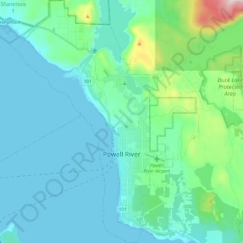
Name: Powell River topographic map, elevation, terrain.
Average elevation: 99 m
Minimum elevation: 0 m
Maximum elevation: 673 m
qathet Regional District trails, hiking, mountain biking, running and outdoor activities
Make a donation
Gear up for your next adventure:
As an Amazon Associate, this site earns from qualifying purchases at no extra cost to you.
Other topographic maps
Click on a map to view its topography, its elevation and its terrain.
Goat Island
Canada > British Columbia > qathet Regional District > Area A (Malaspina/Toba)
Average elevation: 291 m
Boyle Lake
Canada > British Columbia > qathet Regional District > Area A (Malaspina/Toba)
Average elevation: 1,401 m
Lund
Canada > British Columbia > qathet Regional District > Area A (Malaspina/Toba)
Average elevation: 57 m
Mount Shepherd
Canada > British Columbia > qathet Regional District > Area D (Texada Island)
Average elevation: 558 m
Make a donation
Gear up for your next adventure:
As an Amazon Associate, this site earns from qualifying purchases at no extra cost to you.
Van Anda
Canada > British Columbia > qathet Regional District > Area D (Texada Island)
Average elevation: 49 m
Lang Bay
Canada > British Columbia > qathet Regional District > Area C (Lois Lake/Saltery Bay)
Average elevation: 67 m
Lasqueti
Canada > British Columbia > qathet Regional District > Area E (Lasqueti Island) > Lasqueti
Average elevation: 48 m
Page Islets
Canada > British Columbia > qathet Regional District > Area A (Malaspina/Toba)
Average elevation: 30 m
Make a donation
Gear up for your next adventure:
As an Amazon Associate, this site earns from qualifying purchases at no extra cost to you.
Saltery Bay
Canada > British Columbia > qathet Regional District > Area C (Lois Lake/Saltery Bay)
Average elevation: 83 m