
Lund topographic map
Click on the map to display elevation.
About this map
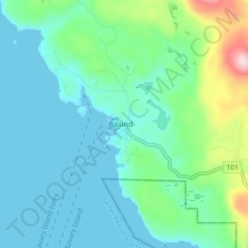
Name: Lund topographic map, elevation, terrain.
Average elevation: 57 m
Minimum elevation: 0 m
Maximum elevation: 282 m
qathet Regional District trails, hiking, mountain biking, running and outdoor activities
Other topographic maps
Click on a map to view its topography, its elevation and its terrain.
Savary Island
Canada > British Columbia > qathet Regional District > Area A (Malaspina/Toba)
Average elevation: 3 m
Gifford Peninsula
Canada > British Columbia > qathet Regional District > Area A (Malaspina/Toba)
Average elevation: 48 m
Goat Island
Canada > British Columbia > qathet Regional District > Area A (Malaspina/Toba)
Average elevation: 291 m
Page Islets
Canada > British Columbia > qathet Regional District > Area A (Malaspina/Toba)
Average elevation: 30 m
Hernando Island
Canada > British Columbia > qathet Regional District > Area A (Malaspina/Toba)
Average elevation: 23 m
Boyle Lake
Canada > British Columbia > qathet Regional District > Area A (Malaspina/Toba)
Average elevation: 1,401 m
Toba Inlet
Canada > British Columbia > qathet Regional District > Area A (Malaspina/Toba)
Average elevation: 795 m