
Make a donation
Gear up for your next adventure:
As an Amazon Associate, this site earns from qualifying purchases at no extra cost to you.
City of Moncton topographic map
Click on the map to display elevation.
Make a donation
Gear up for your next adventure:
As an Amazon Associate, this site earns from qualifying purchases at no extra cost to you.
About this map
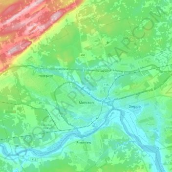
Name: City of Moncton topographic map, elevation, terrain.
Location: City of Moncton, Westmorland County, New Brunswick, Canada (46.04908 -64.92322 46.17578 -64.68658)
Average elevation: 53 m
Minimum elevation: -1 m
Maximum elevation: 204 m
Westmorland County trails, hiking, mountain biking, running and outdoor activities
Make a donation
Gear up for your next adventure:
As an Amazon Associate, this site earns from qualifying purchases at no extra cost to you.
Other topographic maps
Click on a map to view its topography, its elevation and its terrain.
Memramcook Lake
Canada > New Brunswick > Westmorland County > Dorchester Parish
Average elevation: 19 m
Make a donation
Gear up for your next adventure:
As an Amazon Associate, this site earns from qualifying purchases at no extra cost to you.
Haute-Aboujagane
Canada > New Brunswick > Westmorland County > Beaubassin East
Average elevation: 28 m
Make a donation
Gear up for your next adventure:
As an Amazon Associate, this site earns from qualifying purchases at no extra cost to you.