
Graz topographic map
Interactive map
Click on the map to display elevation.
About this map
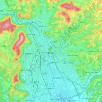
Name: Graz topographic map, elevation, terrain.
Location: Graz, Styria, Austria (47.01189 15.34971 47.13450 15.53420)
Average elevation: 426 m
Minimum elevation: 326 m
Maximum elevation: 749 m
Graz is situated on both sides of the Mur river in southeast Austria. It is about 150 km (93 mi) southwest of Vienna (Wien). The nearest larger urban centre is Maribor (Marburg) in Slovenia, which is about 50 km (31 mi) to the south. Graz is the state capital and largest city in Styria, a green and heavily forested region on the eastern edge of the Alps. It is located in the Graz Basin and surrounded by mountains and hills to the north, east and west. The city center sits at an elevation of 353 m (1,158 ft), the highest point is Plabutsch mountain with 754 m (2,474 ft) at the western border. The mountain Schöckl is just a few kilometers to the north and surmounts the city by 1,100 m (3,600 ft).
Other topographic maps
Click on a map to view its topography, its elevation and its terrain.
Bad Radkersburg
Austria > Styria > Bezirk Südoststeiermark
Bad Radkersburg, Bezirk Südoststeiermark, Styria, 8490, Austria
Average elevation: 221 m
Graden
Austria > Styria > Bezirk Voitsberg > Köflach
Graden, Köflach, Bezirk Voitsberg, Styria, 8580, Austria
Average elevation: 894 m
Feldkirchen bei Graz
Austria > Styria > Bezirk Graz-Umgebung
Feldkirchen bei Graz, Bezirk Graz-Umgebung, Styria, 8073, Austria
Average elevation: 335 m
Erzberg
Austria > Styria > Bezirk Leoben > Eisenerz
Erzberg, Eisenerz, Bezirk Leoben, Styria, 8790, Austria
Average elevation: 1,115 m
Bruck an der Mur
Austria > Styria > Bezirk Bruck-Mürzzuschlag
Bruck an der Mur, Bezirk Bruck-Mürzzuschlag, Styria, 8600, Austria
Average elevation: 827 m
Gemeinde Spital am Semmering
Austria > Styria > Gemeinde Spital am Semmering
Gemeinde Spital am Semmering, Bruck-Mürzzuschlag, Styria, 8684, Austria
Average elevation: 1,158 m
Knittelfeld
Austria > Styria > Bezirk Murtal
Knittelfeld, Bezirk Murtal, Styria, 8720, Austria
Average elevation: 730 m
Vasoldsberg
Austria > Styria > Vasoldsberg
Vasoldsberg, Graz-Umgebung, Styria, 8076, Austria
Average elevation: 415 m
Gössendorf
Austria > Styria > Gössendorf > Gössendorf
Gössendorf, Bezirk Graz-Umgebung, Styria, 8077, Austria
Average elevation: 340 m
Niedere Tauern
Niedere Tauern, Sölk, Gröbming, Liezen, Styria, Austria
Average elevation: 1,207 m